 AI image
Bahamas
Eleuthera
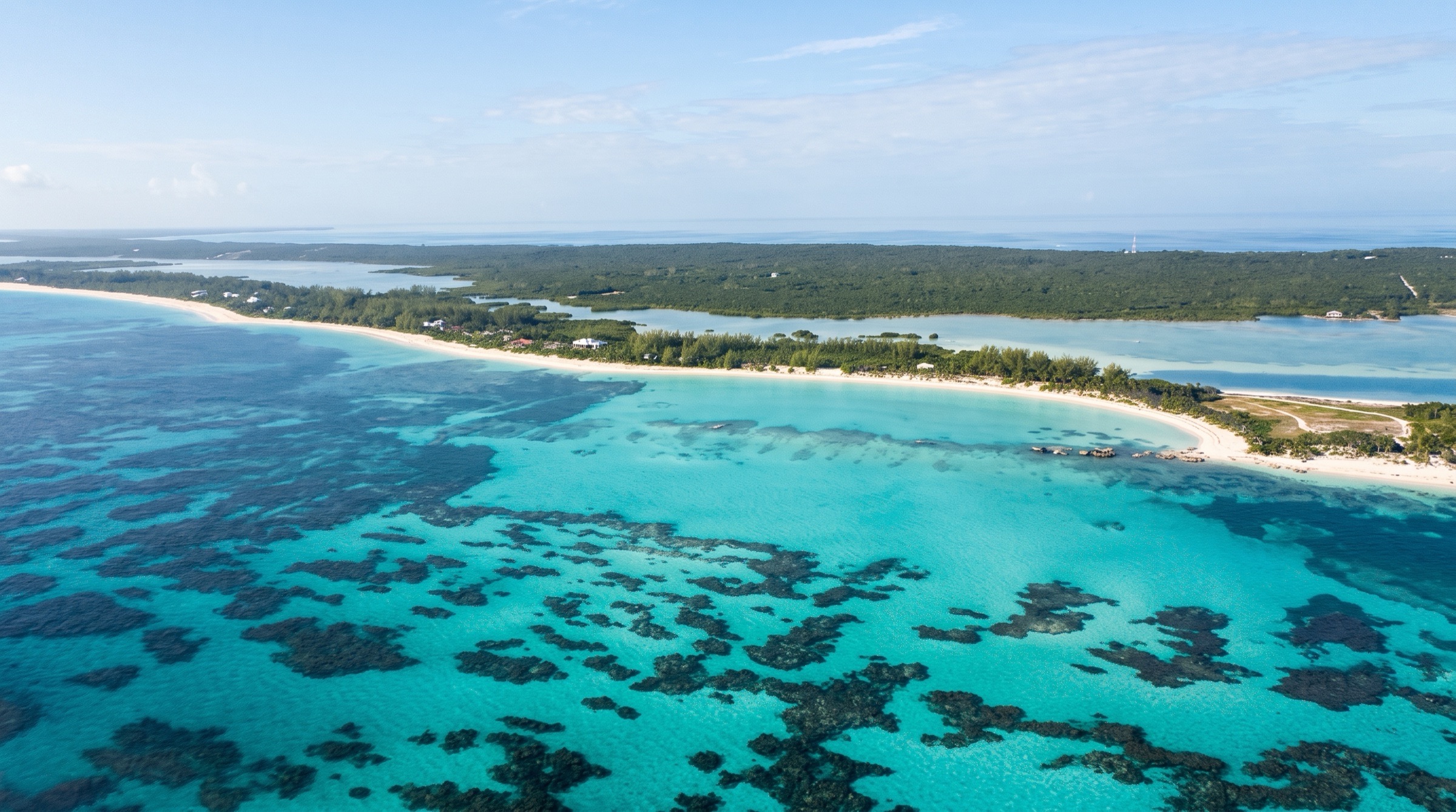
Eleuthera is a long, thin island with pink-sand Atlantic beaches on one side and calm Bahama Bank water on the other. Highlights include Harbour Island's Briland pink sand, the Glass Window Bridge and Hatchet Bay. Anchorages are mostly open to the west, so wind shifts matter, and several entrances need care.
Best months
Difficulty
ModerateFrequent winter fronts, west-facing anchorages and tricky entrances.
Conditions
Easterly trades of 10-20 knots. Winter fronts swing the wind west and north at 20-30 knots, and most anchorages are open to the west, so move to a protected harbor before each front. Atlantic swell breaks on the east coast; Current Cut runs 4+ knots. Hurricane season is June to November.
Area guide
Bahamas — Eleuthera, Andros & the Out Islands
Bahamas
Everything in the central and southern Bahamas outside the Exuma Cays and George Town: Eleuthera (with Spanish Wells and Harbour Island), Andros, Cat Island, Long Island, the 'Far Out Islands' (Conception, Rum Cay, San Salvador), Crooked Island and Acklins with Long Cay, Samana and the Plana Cays, Mayaguana, Great and Little Inagua with Hogsty Reef, and the Jumentos Cays and Ragged Island chain. Eleuthera, about 110 miles long and in places a mile wide, has a well-protected shallow 'Bight' on its west side with Spanish Wells, Hatchet Bay, Governor's Harbour and Rock Sound, and a wild Atlantic east coast. Andros is the largest Bahamian island, ringed on the east by a barrier reef that drops into the Tongue of the Ocean and riddled with blue holes; it is the bonefishing capital of the world. South and east of George Town, the islands get thinner on services and thicker on solitude: Cat Island's Hermitage and fish fries, Long Island's Thompson Bay cruiser community and Dean's Blue Hole, Conception Island's national park, Columbus's landfall at San Salvador, and the remote, east-protected anchorages of the Jumentos and Raggeds. Nearly every anchorage here is on a west-facing (lee) shore, so the rhythm of cruising is set by winter cold fronts that clock the wind through south, west and north. George Town (Elizabeth Harbour) is the usual hub for the southern half; Nassau and Spanish Wells for the north.
Top of the list
- 1Conception Island West Bay AnchorageAn uninhabited national park island with white-sand bays, nesting seabirds and turtles in the creek; widely rated the best anchorage in the southern Bahamas in settled easterlies.
- 2Conception Island Creek (dinghy tour)A high-tide dinghy drift through a mangrove creek full of green turtles, nurse sharks and egrets (4-knot limit inside the creek).
- 3Pink Sands Beach (Harbour Island)Three miles of pink-tinged Atlantic sand on Harbour Island, a short walk from the Dunmore Town docks.
- 4Spanish Wells Town (St. George's Cay)The working lobster-fleet town of north Eleuthera: fuel, boatyards, chandleries and groceries, and the base for the Devil's Backbone run to Harbour Island.
- 5Glass Window BridgeThe roughly 30-ft-wide neck of Eleuthera where the deep-blue Atlantic meets the green Bight; the island's signature viewpoint.
- 6Current Cut drift dive/snorkelThe tide-swept gap between Eleuthera and Current Island; time it at slack and it is the shortcut onto the Eleuthera banks, or a thrilling drift snorkel.
- 7Hatchet Bay HarbourA man-made cut into a near-landlocked pond with all-round protection; the best foul-weather refuge on Eleuthera's bank side.
- 8Rock Sound Ocean HoleAn inland blue hole a short walk from Rock Sound's well-protected anchorage and its supermarket.
- 9Cape Eleuthera Resort & MarinaThe jumping-off marina for the Exuma Sound crossing to the Exuma Cays, with fuel and a port of entry by arrangement.
- 10The Hermitage (Mount Alvernia)Father Jerome's miniature stone monastery on the highest point in the Bahamas, a short hike from the New Bight anchorage.
- 11Fernandez Bay Anchorage (Cat Island)A crescent of sand with good holding, an honor bar ashore and mangrove trails, a favourite Cat Island stop in east winds.
- 12Hawk's Nest Resort & MarinaCat Island's only marina, tucked into a creek at the southwest tip, used to wait out fronts.
- 13Thompson Bay Anchorage (Long Island)The cruiser hub of Long Island at Salt Pond: large, well-protected, with groceries, a chandlery and a cruisers' net.
- 14Dean's Blue HoleOne of the world's deepest known blue holes, beside a beach west of Clarence Town; home of the Vertical Blue freediving event.
- 15Clarence Town Harbour AnchorageThe only port on Long Island's Atlantic side, with Flying Fish Marina, customs, and Father Jerome's twin-spired churches.
- 16Columbus Landfall Monument (Long Bay, San Salvador)San Salvador is the probable site of Columbus's first landfall on October 12, 1492.
- 17Port Nelson Anchorage (Rum Cay)A reef-strewn approach to a sleepy settlement on one of the least-visited islands, with the HMS Conqueror wreck nearby.
- 18Bird Rock LighthouseAn abandoned 19th-century lighthouse off Crooked Island's north tip, a landmark for the Crooked Island Passage.
- 19French Wells AnchorageA well-protected anchorage at the mangrove-lined entrance between Crooked Island and Long Cay, with snorkeling and birding.
- 20Inagua National Park (flamingos)Home to the largest breeding colony of West Indian flamingos in the world (BNT: about 70,000 birds).
- 21Hogsty Reef AnchorageA remote atoll-like reef between Acklins and Inagua; spectacular in settled weather, no shelter in anything else.
- 22Flamingo Cay Two Palms AnchorageA Jumentos anchorage with clean beaches, strong holding and a dinghy-accessible sea cave.
- 23Buenavista Cay AnchorageA mile-long west-side beach in the heart of the Jumentos with excellent views and snorkeling.
- 24Hog Cay Yacht Club (Raggeds)An informal cruiser-built beach bar that is the social centre of the Ragged Island chain.
- 25North Andros Barrier ReefA barrier reef about 140 miles long on Andros's east side, dropping into the 6,000-ft Tongue of the Ocean.
- 26Captain Bill's Blue Hole (Blue Holes National Park)Andros has the world's largest collection of blue holes; this park protects the most visited of them.
When to go
The main cruising season is roughly December to May, when the easterly trades blow and most cruisers migrate between Eleuthera, the Exumas, Long Island and the southern islands. Winter (December–March) brings regular cold fronts every few days to a week, with strong winds clocking from south through west to north; most anchorages in this area are open to the west, so plan to move to a front-proof spot (Hatchet Bay, Rock Sound, Hawk's Nest creek, Thompson Bay, Clarence Town or a marina) before each front. Spring (April–June) has lighter winds and the best weather for the remote Jumentos, Raggeds, Crooked/Acklins and Inagua. Summer is hot and calm with afternoon squalls, biting insects (Andros, Inagua) and hurricane risk.
Weather and hazards
Cold fronts: in winter, west-facing anchorages (Cat Island's west coast, Calabash Bay, the Jumentos, Landrail Point, Matthew Town) become untenable as wind clocks west and north; noforeignland reviews repeatedly flag these as rolly or exposed. Atlantic coasts of Eleuthera, Cat, Long Island and the Far Out Islands are steep, rocky and exposed; only Clarence Town and Little Harbour on Long Island offer east-side shelter, and Harbour Island's entrances need care (shifting sand and the Devil's Backbone reef). Tidal cuts: Current Cut runs at 4+ knots at times and Fresh Creek's entrance rips on the ebb (around 3 knots inside). 'Rage' in the cuts and reef passes when swell opposes the tide. Coral heads: reading water in good overhead light is essential at Rum Cay (Port Nelson), Abraham's Bay (Mayaguana), Crooked Island Marina's approach and in the Jumentos, where guides warn charts are less accurate. Restricted areas: the U.S. Navy AUTEC range off Fresh Creek, Andros is off limits. Wildlife: bull sharks are frequent in the Jumentos, especially around spearfishing; horse flies, no-see-ums and mosquitoes on Andros and Inagua in warm months. Remote services: from Long Island south there is little or no fuel, water, chandlery or medical care; be self-sufficient, and expect intermittent cell coverage south of Long Island. After Hurricane Melissa (2025), recent reviews note damage affecting dinghy access at Thompson Bay; check current reports.
Hurricane season
Atlantic hurricane season runs June 1 to November 30, peaking around September 10 with most activity mid-August to mid-October (NOAA NHC). The southern Bahamas lie on a common hurricane track (Irma devastated Ragged Island in 2017; Melissa in 2025 caused damage in the southern islands). Few true hurricane holes exist in this area; Hatchet Bay (Eleuthera) and Hawk's Nest creek (Cat Island) are cited by cruisers as storm refuges but are not substitutes for leaving the hurricane belt or a professional haul-out. Most insurers require boats to be north of a specified latitude or hauled for the season; check your policy.
Entry and clearance
All arriving foreign yachts must clear at a designated Port of Entry with the Q flag up; only the captain goes ashore until cleared. Since 2021 the cruising permit is applied for and paid online through the Bahamas Customs Click2Clear portal (Cruising Permit module: Pleasure Vessel → Pleasure Craft → Create Inbound), then stamped and signed in person by a Customs officer at the port. Customs ports of entry in this area listed by Bahamas Customs include: Harbour Island (public dock, Harbour Island Marina, Romora Bay, Valentines), Spanish Wells (public dock, Yacht Haven), North Eleuthera (airport, Three Island Dock), Governor's Harbour (airport, public dock, French Leave), Rock Sound (airport; Cape Eleuthera restricted/by arrangement), Andros (Fresh Creek airport and public dock, San Andros airport and public dock at Morgan's Bluff, Congo Town airport), Cat Island (New Bight and Smith's Bay airports, Smith's Bay, Bennett's Harbour and Arthur's Town public docks), Long Island (Stella Maris airport, public dock and marina, Simms and Salt Pond public docks, Clarence Town public dock, Deadman's Cay airport), San Salvador (airport, public dock, Riding Rock Marina), Crooked Island (Colonel Hill airport and public dock) and Inagua (airport and public dock, Matthew Town). Mayaguana's Abraham's Bay is described by Noonsite and Waterway Guide as a port of entry, but officials commute from Inagua and a February 2023 report said clearance there was not possible; confirm before relying on it. Customs offices typically keep 9:00 am to 5:00 pm hours. Outbound clearance ($75) is only needed if the next country requires clearance papers.
Permits and fees
Bahamas Customs fees (as published on bahamascustoms.gov.bs, fee schedule effective July 1, 2025; USD/BSD at par): 30-day temporary cruising permit $150 (≤30 ft), $250 (30–50 ft), $350 (50–100 ft), $600 (>100 ft), no free re-entry; 6-month permit $300 (≤50 ft), $750 (50–100 ft), $2,000 (>100 ft), one free re-entry; 12-month permit $500 (≤50 ft), $1,000 (50–100 ft), $3,000 (>100 ft), two free re-entries. Fees include Customs and Immigration attendance and transport. Anchorage fee for foreign vessels that anchor rather than use marinas, paid once per permit: 30-day $50/$100/$200, 6-month $150/$350/$1,000, 12-month $200/$350/$1,500 (≤50 / 50–100 / >100 ft). Fishing permit $100 (<50 ft) or $300 (>50 ft), valid 30 days only and not included in the cruising permit. Passenger arrival tax $20 per person when the vessel carries more than three non-resident crew/passengers aged six or older. A 2-year Frequent Digital Cruising Card (FDCC) is also offered. Foreign-owned vessels 50 ft and over must keep AIS on in Bahamian waters (Noonsite, 2025). Park fees: Conception Island, Inagua and Andros parks are managed by the Bahamas National Trust; the whole Bahamas has a closed crawfish (lobster) season (verify current dates and bag limits with the Department of Marine Resources).
Tides and currents
Semi-diurnal tides with a range of roughly 2.5–3.5 ft across the Bahamas; most cruising guides reference predictions for Nassau with time and height corrections for other locations. Tidal streams are strongest in narrow cuts: Current Cut (Eleuthera) runs at 4+ knots at times and must be taken near slack; Fresh Creek (Andros) ebbs near 3 knots; Conception Island's creek and the Duncan Town trench are tide-dependent for dinghies. On the banks, many approaches (Stella Maris, Dollar Harbour, Abraham's Bay dinghy dock, Fresh Creek government dock) are best on a rising tide. Offshore, the Antilles Current sets generally northwest along the outer islands and through the Crooked Island and Mayaguana passages.
Money
Bahamian dollar (BSD), pegged 1:1 to the US dollar; US dollars are accepted everywhere. Cards work at marinas and larger stores in Eleuthera, Long Island and Andros Town; carry cash for the southern islands, fish fries, mailboat freight and small settlements, where ATMs are few or absent.
Radio and phones
VHF 16 for hailing and safety; marinas and many businesses answer on VHF 16 (some switch to working channels). Local cruisers' nets run in season, notably the Long Island (Thompson Bay/Salt Pond) cruisers' net; check locally for the current channel and time. Cell service (BTC and Aliv) is good around Eleuthera, Andros Town and Long Island settlements but intermittent or absent across Conception, the Jumentos, Crooked/Acklins and parts of Mayaguana and Inagua; satellite messaging or Starlink is recommended for weather south of Long Island.
Charter bases
- No major bareboat bases in this areaBareboat fleets operate from Nassau (New Providence) and the Abacos; Exuma bases are in George Town/Emerald Bay. Charterers usually reach Eleuthera from Nassau across the Northeast Providence Channel or from the Exumas across Exuma Sound.
Getting there
- Lynden Pindling International Airport, Nassau — NASMain international gateway; domestic connections to every island below.
- Exuma International Airport, Moss Town — GGTGateway for George Town, the usual hub for Long Island, Conception and the Jumentos.
- North Eleuthera Airport — ELHFor Spanish Wells and Harbour Island (water taxis from Three Island Dock).
- Governor's Harbour Airport — GHBCentral Eleuthera; also a Customs port of entry.
- Rock Sound International Airport — RSDSouth Eleuthera, near Rock Sound and Cape Eleuthera.
- San Andros Airport — SAQNorth Andros, near Nicholls Town and Morgan's Bluff.
- Andros Town Airport (Fresh Creek) — ASDCentral Andros, Fresh Creek.
- Clarence A. Bain Airport, Mangrove Cay — MAYMangrove Cay, Andros.
- South Andros Airport (Congo Town) — TZNSouth Andros.
- Arthur's Town Airport — ATCNorth Cat Island.
- New Bight Airport — TBICentral Cat Island near the New Bight anchorage.
- Stella Maris Airport — SMLNorth Long Island.
- Deadman's Cay Airport — LGICentral Long Island.
- San Salvador Airport (Cockburn Town) — ZSASan Salvador.
- Port Nelson Airport — RCYRum Cay.
- Colonel Hill Airport — CRICrooked Island.
- Spring Point Airport — AXPAcklins.
- Mayaguana Airport — MYGMayaguana.
- Inagua Airport (Matthew Town) — IGAGreat Inagua.
- Duncan Town Airport — DCTRagged Island.
Charts and guides
- Explorer Chartbooks: Near Bahamas, Exumas & Ragged Islands, and Far Bahamas (Monty and Sara Lewis) — the standard surveyed chartbooks for this area
- Waterway Guide: Bahamas edition
- Stephen J. Pavlidis, 'The Southern Bahamas' and 'The Exuma Guide' cruising guides (Seaworthy Publications)
- Navionics / Garmin electronic charts (verify against Explorer Chartbook and satellite imagery on the banks)
- noforeignland Bahamas area guides (community-rated anchorages, marinas and clearance offices)
- Noonsite Bahamas (formalities, fees, ports of entry)
- Bahamas Customs Click2Clear portal and fee schedule
- Bahamas National Trust park pages (Conception Island, Inagua, Andros, San Salvador parks)
Sample routes
- 7 days: Eleuthera end to end (Spanish Wells to Cape Eleuthera)Day 1 · Spanish Wells Town (St. George's Cay) → Harbour Island Anchorage (off Dunmore Town) · 9 nmDevil's Backbone with a local pilot; Pink Sands Beach. Distances approximate.Day 2 · Harbour Island Anchorage (off Dunmore Town) → Royal Island Harbour Anchorage · 14 nmBack around via Spanish Wells; landlocked harbour.Day 3 · Royal Island Harbour Anchorage → Current Settlement and Current Island Anchorage · 8 nmTransit Current Cut at slack; drift snorkel.Day 4 · Current Settlement and Current Island Anchorage → Hatchet Bay Harbour · 18 nmGlass Window Bridge by road from Gregory Town; Hatchet Bay Cave.Day 5 · Hatchet Bay Harbour → Governor's Harbour Anchorage · 16 nmFriday fish fry, Cupid's Cay, Atlantic beach walk.Day 6 · Governor's Harbour Anchorage → Rock Sound North Anchorage · 25 nmOcean Hole, provisioning at the supermarket.Day 7 · Rock Sound North Anchorage → Cape Eleuthera Resort & Marina · 15 nmFuel up for the Exuma Sound crossing; Lighthouse Beach by road.
- 10 days: George Town loop to Conception, Rum Cay, San Salvador and Cat IslandDay 1 · George Town (Elizabeth Harbour) → Calabash Bay Anchorage · 30 nmExuma Sound to Cape Santa Maria; Columbus Monument. Distances approximate.Day 2 · Calabash Bay Anchorage → Conception Island West Bay Anchorage · 16 nmNational park arrival; beach walk.Day 3 · Conception Island West Bay Anchorage → Conception Island West Bay Anchorage · 0 nmHigh-tide dinghy tour of the creek; turtles; reef snorkel.Day 4 · Conception Island West Bay Anchorage → Port Nelson Anchorage (Rum Cay) · 20 nmGood light for the reef approach; HMS Conqueror wreck.Day 5 · Port Nelson Anchorage (Rum Cay) → Cockburn Town Anchorage (San Salvador) · 35 nmClear or visit Riding Rock; Columbus landfall.Day 6 · Cockburn Town Anchorage (San Salvador) → Cockburn Town Anchorage (San Salvador) · 0 nmWall dive; Dixon Hill Lighthouse; Long Bay monument.Day 7 · Cockburn Town Anchorage (San Salvador) → Hawk's Nest Resort & Marina · 55 nmLong open-water leg to Cat Island's south tip.Day 8 · Hawk's Nest Resort & Marina → New Bight Anchorage · 15 nmHike to The Hermitage; New Bight fish fry.Day 9 · New Bight Anchorage → Fernandez Bay Anchorage (Cat Island) · 3 nmHonor bar, mangrove trails.Day 10 · Fernandez Bay Anchorage (Cat Island) → George Town (Elizabeth Harbour) · 55 nmReturn across Exuma Sound, or continue north to Little San Salvador and Eleuthera.
- 14 days: Long Island and the Jumentos & RaggedsDay 1 · George Town (Elizabeth Harbour) → Thompson Bay Anchorage (Long Island) · 38 nmBanks route to Salt Pond; cruisers' net. Distances approximate.Day 2 · Thompson Bay Anchorage (Long Island) → Thompson Bay Anchorage (Long Island) · 0 nmRent a car: Dean's Blue Hole, Hamilton's Cave, Clarence Town churches.Day 3 · Thompson Bay Anchorage (Long Island) → Fisherman's Bay Anchorage (Great Water Cay) · 40 nmAcross the banks to the Jumentos via the Thompson Bay to Water Cay route; first Jumentos anchorage, no cell service.Day 4 · Fisherman's Bay Anchorage (Great Water Cay) → Fisherman's Bay Anchorage (Great Water Cay) · 0 nmExplore the Water Cay blue holes and beaches by dinghy.Day 5 · Fisherman's Bay Anchorage (Great Water Cay) → Flamingo Cay Two Palms Anchorage · 12 nmDinghy into the sea cave; trails.Day 6 · Flamingo Cay Two Palms Anchorage → Buenavista Cay Anchorage · 28 nmMile-long beach, lobster grounds near Rick's Cay.Day 7 · Buenavista Cay Anchorage → Double Breasted Cay Anchorage · 15 nmCave, trails, kite flats.Day 8 · Double Breasted Cay Anchorage → Hog Cay Anchorage (Raggeds) · 10 nmHog Cay Yacht Club sundowners.Day 9 · Hog Cay Anchorage (Raggeds) → Hog Cay Anchorage (Raggeds) · 0 nmDinghy up the trench to Duncan Town (tide-dependent).Day 10 · Hog Cay Anchorage (Raggeds) → Raccoon Cay House Bay Anchorage · 12 nmSheltered from easterlies; family beach.Day 11 · Raccoon Cay House Bay Anchorage → Johnson Cay Anchorage · 6 nmSnorkel and spearfish (beware bull sharks).Day 12 · Johnson Cay Anchorage → Flamingo Cay North Bight Anchorage · 34 nmNorthbound; good in southerlies before a front.Day 13 · Flamingo Cay North Bight Anchorage → Fisherman's Bay Anchorage (Great Water Cay) · 12 nmStage for the run back to the Exumas.Day 14 · Fisherman's Bay Anchorage (Great Water Cay) → George Town (Elizabeth Harbour) · 50 nmAcross the bank to Hog Cay Cut and up Exuma Sound to George Town.
- 14 days: The Thorny Path south (Long Island to Inagua)Day 1 · Thompson Bay Anchorage (Long Island) → Clarence Town Harbour Anchorage · 55 nmRound Cape Santa Maria; Flying Fish Marina. Distances approximate.Day 2 · Clarence Town Harbour Anchorage → Clarence Town Harbour Anchorage · 0 nmDean's Blue Hole; wait for a weather window.Day 3 · Clarence Town Harbour Anchorage → Landrail Point Anchorage · 45 nmAcross the Crooked Island Passage; Bird Rock Lighthouse.Day 4 · Landrail Point Anchorage → French Wells Anchorage · 10 nmMangrove creek by dinghy; birding.Day 5 · French Wells Anchorage → Long Cay (Fortune Island) East Anchorage · 8 nmAlbert Town ruins.Day 6 · Long Cay (Fortune Island) East Anchorage → Castle Island Anchorage · 30 nmLighthouse; wreck snorkel.Day 7 · Castle Island Anchorage → Hogsty Reef Anchorage · 40 nmOnly in settled weather; wrecks and pristine reef.Day 8 · Hogsty Reef Anchorage → Man of War Bay North Anchorage (Great Inagua) · 40 nmProtected from easterlies.Day 9 · Man of War Bay North Anchorage (Great Inagua) → Matthew Town Anchorage · 9 nmCustoms; provisions; lighthouse climb.Day 10 · Matthew Town Anchorage → Matthew Town Anchorage · 0 nmInagua National Park flamingo tour with the warden; Morton Salt.Day 11 · Matthew Town Anchorage → Little Inagua South-West Anchorage · 48 nmUninhabited national park island.Day 12 · Little Inagua South-West Anchorage → Abraham's Bay Reef Anchorage West (Low Point Pass) · 55 nmReef entrance in good light.Day 13 · Abraham's Bay Reef Anchorage West (Low Point Pass) → Abraham's Bay Reef Anchorage West (Low Point Pass) · 0 nmSettlement visit by dinghy at high tide.Day 14 · Abraham's Bay Reef Anchorage West (Low Point Pass) → Providenciales (Turks & Caicos) · 50 nmAcross the Caicos Passage, or return north via the Plana Cays.
Places in Bahamas — Eleuthera, Andros & the Out Islands
- 1648 Restaurant (French Leave)Eat · Eleuthera
- Abraham's Bay ATM and cash (Mayaguana)Service · Mayaguana
- Abraham's Bay Government Dock (dinghy landing)Service · Mayaguana
- Abraham's Bay port of entry status (Mayaguana)Permit · Mayaguana
- Abraham's Bay Reef Anchorage East (Guano Point)Anchorage · Mayaguana
- Abraham's Bay Reef Anchorage West (Low Point Pass)Anchorage · Mayaguana
- Abraham's Bay settlement shops and fuel deliveryStores · Mayaguana
- Abraham's Bay Town Anchorage (inner bay)Anchorage · Mayaguana
- Abraham's Bay Town SquareLandmark · Mayaguana
- Acklins Cascarilla Heritage FestivalEvent · Acklins Island
- Acklins fuel (Spring Point and Snug Corner)Service · Acklins Island
- Acklins Island Lodge (Mason's Bay)Eat · Acklins Island
- Acklins Island Regatta (Spring Point)Event · Acklins Island
- Acquapazza Ristorante (Harbour Island)Eat · Harbour Island
- Adderley's Plantation ruinsHike · Long Island
- Adley's supermarket and Mabel's Meat Mart (Fresh Creek)Stores · North Andros
- Airport Inn Restaurant & Bar (Spring Point Airport)Eat · Acklins Island
- Alabaster Bay AnchorageAnchorage · Eleuthera
- Alabaster Beach SnorkelSnorkel · Eleuthera
- Alabaster Cove North Anchorage (Pelican Cay)Anchorage · Eleuthera
- Albert Town (Long Cay)Landmark · Long Cay (Fortune Island)
- Alice Town (Hatchet Bay) fuel, water and groceriesStores · Eleuthera
- All Mayaguana RegattaEvent · Mayaguana
- All My Children store (Abraham's Bay)Stores · Mayaguana
- Alligator Bay AnchorageAnchorage · Long Island
- Alligator Point AnchorageAnchorage · Cat Island
- Andros bonefish flatsFishing · Mangrove Cay
- Andros Crabfest (Fresh Creek)Event · North Andros
- Andros horse flies and mosquitoes (summer)Seasonal · North Andros
- Andros hurricane seasonSeasonal · Andros (all islands)
- Andros iguanaWildlife · North Andros
- Andros Lighthouse (Fresh Creek)Landmark · North Andros
- Andros Lighthouse Yacht Club & Marina (Fresh Creek)Marina · North Andros
- Andros tourist office (Fresh Creek)Service · North Andros
- Andros Town Airport (ASD)Service · North Andros
- Andros Town groceries, market and fuelStores · North Andros
- Androsia Batik FactoryLandmark · North Andros
- Angel's Da After Work Bar (Pirate's Well)Bar · Mayaguana
- Angela's Starfish (Harbour Island)Eat · Harbour Island
- Annie Bight AnchorageAnchorage · Eleuthera
- Apple Hole Farm Meat Mart & Deli (Rock Sound)Stores · Eleuthera
- Armbrister Plantation ruinsLandmark · Cat Island
- Arthur's Bakery (Harbour Island)Stores · Harbour Island
- Arthur's Town Airport (ATC)Service · Cat Island
- Arthur's Town AnchorageAnchorage · Cat Island
- Arthur's Town nurse practitionerService · Cat Island
- Arthur's Town Public Dock (port of entry)Permit · Cat Island
- Atlantic beach walk from Salt PondHike · Long Island
- Atlantic Fisheries (Salt Pond seafood)Stores · Long Island
- Attwood Harbour Anchorage (Acklins)Anchorage · Acklins Island
- Attwood Harbour beach (Acklins Atlantic shore)Beach · Acklins Island
- Attwood Harbour mangroves (turtles and rays)Wildlife · Acklins Island
- Audrey's store (Abraham's Bay)Stores · Mayaguana
- AUTEC restricted area (U.S. Navy)Permit · North Andros
- Bacchus Fine Foods (Governor's Harbour)Stores · Eleuthera
- Bahama orioleWildlife · North Andros
- Bahama parrot and Inagua woodstarWildlife · Great Inagua
- Bahamas Coffee Roasters and Sweet Spot Cafe (Harbour Island)Eat · Harbour Island
- Bain Town Community Clinic (south Cat Island)Service · Cat Island
- Bandit's Moorings (Spanish Wells Harbour)Anchorage · St. George's Cay (Spanish Wells)
- Bank Anchorage north of the JoultersAnchorage · Joulter Cays
- Bank of The Bahamas and ATM (Matthew Town)Service · Great Inagua
- Bank of The Bahamas ATM (Cockburn Town)Service · San Salvador
- Bannerman TownLandmark · Eleuthera
- Bar 480 (Briland Club Marina)Bar · Harbour Island
- Barbie's Snack (Tarpum Bay)Eat · Eleuthera
- Basil Rock snorkelSnorkel · Eleuthera
- Bathing Beach and Shell Beach (Crooked Island west coast)Beach · Crooked Island
- Baycaner Beach Resort restaurant and car rental (Pirate's Well)Eat · Mayaguana
- Below Deck Beach Bar & Grill (Morgan's Bluff)Bar · North Andros
- Ben Bay Beach (North Eleuthera)Beach · Eleuthera
- Ben Bluff AnchorageAnchorage · Cat Island
- Bennett's Harbour (Pompey Rock) AnchorageAnchorage · Cat Island
- Bennett's Harbour Public Dock (port of entry)Permit · Cat Island
- Bethel Channel AnchorageAnchorage · North Andros
- Betsy Bay Anchorage (Mayaguana)Anchorage · Mayaguana
- Betsy Bay beach (Mayaguana)Beach · Mayaguana
- Betsy Bay settlement services (Mayaguana)Service · Mayaguana
- Between the Raggeds AnchorageAnchorage · Ragged Island
- Between the Raggeds outer reefSnorkel · Ragged Island
- Big 'O' & Angie's Place (Matthew Town)Bar · Great Inagua
- Bight of Acklins flatsFishing · Acklins Island
- Bight of Eleuthera pot-buoy linesSeasonal · Eleuthera
- Bird Rock LighthouseLandmark · Crooked Island
- Blackwood Point flamingos (Mayaguana)Wildlife · Mayaguana
- Blue Holes National ParkHike · North Andros
- BNT bird well (Conception)Landmark · Conception Island
- Boiling Hole (Rock Sound)Landmark · Eleuthera
- Bonefish Bay BeachBeach · San Salvador
- Booby CayWildlife · Booby Cay
- Booby Cay Anchorage (Conception)Anchorage · Conception Island
- Bottom Harbour Sea TurtlesWildlife · Eleuthera
- Briland On The Go and Johnson's (Harbour Island gas)Service · Harbour Island
- Buccaneer ClubEat · Eleuthera
- Budda's Snack Shack (Spanish Wells)Eat · St. George's Cay (Spanish Wells)
- Budget Convenience Store and Cash and Carry (Matthew Town)Stores · Great Inagua
- Buenavista Cay AnchorageAnchorage · Buenavista Cay
- Buenavista Cay trails and Edwards ruinsHike · Buenavista Cay
- Busted Bridge Bar & Grill (Newton Cay Beach)Bar · Long Island
- Caerula Mar Club (Driggs Hill)Eat · South Andros
- Calabash Bay AnchorageAnchorage · Long Island
- Calabash Bay bonefish flatsFishing · Long Island
- Calabash Bay North Anchorage (Hoosie Harbour)Anchorage · Long Island
- Calabash Restaurant & Hemingway's Bar (Lighthouse Yacht Club)Eat · North Andros
- Calm Bay Anchorage (Great Inagua north-east)Anchorage · Great Inagua
- Calypso Cafe (North Eleuthera Airport)Eat · Eleuthera
- Camel Point Anchorage (Delectable Bay)Anchorage · Acklins Island
- Cape Eleuthera Dive Shop (Ocean Fox)Tour · Eleuthera
- Cape Eleuthera fuel dockService · Eleuthera
- Cape Eleuthera Marina South AnchorageAnchorage · Eleuthera
- Cape Eleuthera Resort & MarinaMarina · Eleuthera
- Cape Eleuthera Wall (Exuma Sound drop-off)Dive · Eleuthera
- Cape Santa MariaView · Long Island
- Cape Santa Maria Beach (Calabash Bay)Beach · Galliot Cay
- Cape Santa Maria Beach ResortEat · Galliot Cay
- Cape Santa Maria North AnchorageAnchorage · Long Island
- Cape Santa Maria reefs snorkel trips (Calabash Bay)Snorkel · Long Island
- Captain Bill's Blue Hole (Blue Holes National Park)Hike · North Andros
- Cargill CreekFishing · North Andros
- Cartwright Wash House (laundromat)Service · Long Island
- Cascarilla bark harvestSeasonal · Acklins Island
- Castle Island AnchorageAnchorage · Castle Island
- Castle Island LighthouseLandmark · Castle Island
- Castle Island wreck snorkelSnorkel · Castle Island
- Casuarina Pines Villas restaurant (Seahorse Shores)Eat · Crooked Island
- Cat Island Dive Centre (Greenwood Beach Resort)Dive · Cat Island
- Cat Island hurricane seasonSeasonal · Cat Island
- Cat Island Rake 'n' Scrape FestivalEvent · Cat Island
- Cat Island RegattaEvent · Cat Island
- Cat Island west-coast exposure in frontsSeasonal · Cat Island
- Cathedral CaveHike · Eleuthera
- Cay Verde frigatebird rookeryWildlife · Cay Verde
- Channel Cay (Nurse Channel)Landmark · Channel Cay
- Charles Island AnchorageAnchorage · St. George's Cay (Spanish Wells)
- Chester's Highway Inn bonefish lodge (Chesters)Eat · Acklins Island
- Chesters settlement (Acklins)Stores · Acklins Island
- Chez Pierre restaurantEat · Long Island
- Church Grove Landing (Long Cay ferry dock)Service · Crooked Island
- CIBC FirstCaribbean (Governor's Harbour)Service · Eleuthera
- Cistern Rock / Bottom Harbour AnchorageAnchorage · Eleuthera
- Clarence A. Bain Airport (Mangrove Cay, MAY)Service · Mangrove Cay
- Clarence Town East Anchorage (Strachan Cay / Sandy Point)Anchorage · Long Island
- Clarence Town Government ClinicService · Long Island
- Clarence Town government packing house (produce and fish)Stores · Long Island
- Clarence Town Harbour AnchorageAnchorage · Long Island
- Clarence Town harbour sharks and turtlesWildlife · Long Island
- Clarence Town laundry (Flying Fish Marina)Service · Long Island
- Clarence Town Public Dock & Customs (port of entry)Permit · Long Island
- Clingers fried fish (Fresh Creek)Eat · North Andros
- Club Med Columbus IsleEat · San Salvador
- Clyde's Wall (Conception)Dive · Conception Island
- Cockburn TownLandmark · San Salvador
- Cockburn Town Anchorage (San Salvador)Anchorage · San Salvador
- Cockburn Town clinicService · San Salvador
- Cockburn Town Fossil ReefLandmark · San Salvador
- Cockburn Town fuel stationService · San Salvador
- Cockburn Town government basinAnchorage · San Salvador
- Cockburn Town groceries and bakeryStores · San Salvador
- Coco Bay Anchorage (Little Ragged Island)Anchorage · Little Ragged Island
- Coco Bay beach (Little Ragged Island)Beach · Little Ragged Island
- Cold fronts and anchorage choice (Crooked/Acklins)Seasonal · Crooked Island
- Cold-front exposure in the Jumentos (west-side anchorages)Seasonal · Buenavista Cay
- Cold-front season (Rock Sound and Hatchet Bay refuges)Seasonal · Eleuthera
- Colonel Hill Airport and Public Dock (Crooked Island port of entry)Permit · Crooked Island
- Colonel Hill Community ClinicService · Crooked Island
- Colonel Hill lookoutView · Crooked Island
- Colonel Hill settlementStores · Crooked Island
- Columbus BankFishing · Ragged Island
- Columbus Harbour beaches and snorkelBeach · Long Island
- Columbus Landfall Monument (Long Bay, San Salvador)Landmark · San Salvador
- Columbus Monument (Long Island)View · Long Island
- Columbus Monument trail and Columbus Harbour walkHike · Long Island
- Columbus PointView · Cat Island
- Columbus Point wall diveDive · Cat Island
- Columbus Tavern (North Victoria Hill)Bar · San Salvador
- Columbus underwater monument (Long Bay)Dive · San Salvador
- Columbus World Centre Museum (Knowles)Landmark · Cat Island
- Conception Bank silver boaWildlife · Conception Island
- Conception Island Creek (dinghy tour)Wildlife · Conception Island
- Conception Island East Bay AnchorageAnchorage · Conception Island
- Conception Island hiking trailsHike · Conception Island
- Conception Island moorings (West Bay)Anchorage · Conception Island
- Conception Island National ParkPermit · Conception Island
- Conception Island reefsSnorkel · Conception Island
- Conception Island settlement ruinsLandmark · Conception Island
- Conception Island South AnchorageAnchorage · Conception Island
- Conception Island Wall (Savo Wall)Dive · Conception Island
- Conception Island West Bay AnchorageAnchorage · Conception Island
- Conception seabird nesting caysWildlife · Booby Cay (Conception)
- Conch Bay coral heads (North Andros)Snorkel · North Andros
- Conch SoundLandmark · North Andros
- Conch Sound Oceanic Blue HoleSnorkel · North Andros
- Congo Town (South Andros Airport, TZN)Permit · South Andros
- Coral Gardens (Stella Maris shore snorkel)Snorkel · Long Island
- Cotton Bay BeachBeach · Eleuthera
- Cozy Corner Restaurant & Bar (Matthew Town)Eat · Great Inagua
- Crab Replenishment ReserveWildlife · North Andros
- Crooked Island and Acklins birdingWildlife · Crooked Island
- Crooked Island car rental and transportService · Crooked Island
- Crooked Island Homecoming Festival (Colonel Hill)Event · Crooked Island
- Crooked Island mailboatService · Crooked Island
- Crooked Island Marina (Landrail Point)Marina · Crooked Island
- Crooked Island mechanics and marine partsService · Crooked Island
- Crooked Island South AnchorageAnchorage · Crooked Island
- Crooked Island wall divesDive · Crooked Island
- Crooked Island–Acklins ferry (Cove Point to Lovely Bay)Service · Acklins Island
- Crooked/Acklins limited comms and suppliesSeasonal · Crooked Island
- Cross Cay Anchorage (North Andros west side)Anchorage · North Andros
- Cupid's CayLandmark · Cupid's Cay
- Cupid's Cay South Anchorage (old mooring blocks)Anchorage · Cupid's Cay
- Current Bay Beach (North Eleuthera)Beach · Eleuthera
- Current Cut drift dive/snorkelDive · Current Island
- Current Cut shoreline walkHike · Eleuthera
- Current Settlement and Current Island AnchorageAnchorage · Eleuthera
- Curtis Creek (Mayaguana)Watersport · Mayaguana
- Da Blue Marlin and Pool Bar (Cape Eleuthera)Bar · Eleuthera
- Da Island Kitchen at Pompey RocksEat · Cat Island
- Da Perk Coffee Shop (Governor's Harbour)Eat · Eleuthera
- Da Smoke Pot restaurant (Arthur's Town)Eat · Cat Island
- Da Vine (Harbour Island)Eat · Harbour Island
- Daddy Joe's Bar & Restaurant (near Glass Window)Eat · Eleuthera
- Davis Harbour fuel dock and servicesService · Eleuthera
- Davis Harbour MarinaMarina · Eleuthera
- Dayshell Motel Restaurant & Bar (Nicholls Town)Eat · North Andros
- Deadman's Cay Airport (LGI)Service · Long Island
- Deadman's Cay banks and ATMs (Scotiabank and RBC)Service · Long Island
- Deadman's Cay flats anchorageFishing · Long Island
- Deadman's Cay Government ClinicService · Long Island
- Deadman's Cay groceries and fuelStores · Long Island
- Deals BeachBeach · Long Island
- Dean's Blue HoleSnorkel · Long Island
- Deep CreekLandmark · Eleuthera
- Deep Creek BeachBeach · Eleuthera
- Deveaux Mansion ruins (Port Howe)Landmark · Cat Island
- Devil's Backbone reef and wrecksDive · Eleuthera
- Devil's Claw (San Salvador)Dive · San Salvador
- Devil's Point drop-off (Great Inagua)Snorkel · Great Inagua
- Dilda Rocks AnchorageAnchorage · Long Island
- Discovery Day Festival & Homecoming (San Salvador)Event · San Salvador
- Disney Lookout Cay (Lighthouse Point)Landmark · Eleuthera
- Dixon Hill LighthouseView · San Salvador
- Dollar Cay Harbour AnchorageAnchorage · Dollar Cay
- Dolphin Blow Hole Bar & Grill (Tarpum Bay)Eat · Eleuthera
- Dorsett's Laundromat (Smith Bay)Service · Cat Island
- Double Bay BeachBeach · Eleuthera
- Double Bay SnorkelSnorkel · Eleuthera
- Double Breasted Cay AnchorageAnchorage · Double Breasted Cay
- Double Breasted Cay cave, trails and kitesurf flatsWatersport · Double Breasted Cay
- Double Caves (San Salvador)Dive · San Salvador
- Down Home / In The Valley Take-Out (North Victoria Hill)Eat · San Salvador
- Driggs Hill Customs (South Andros)Permit · South Andros
- Driggs Hill Government BasinMarina · South Andros
- Driggs Hill propane and shopsService · South Andros
- Driggs Hill service station (fuel)Service · South Andros
- Dumfries AnchorageAnchorage · Cat Island
- Duncan TownStores · Ragged Island
- Duncan Town Airport (DCT)Service · Ragged Island
- Duncan Town churchLandmark · Ragged Island
- Duncan Town clinicService · Ragged Island
- Duncan Town cruisers' feast (February)Event · Hog Cay (Raggeds)
- Duncan Town Government Dock (dinghy landing)Service · Ragged Island
- Duncan Town Harbour Anchorage (Ragged Island)Anchorage · Ragged Island
- Duncan Town salt pondsLandmark · Ragged Island
- Dunmore Town historic districtLandmark · Harbour Island
- Durham's General Store (Current)Stores · Eleuthera
- East & Final Grocery (James Cistern)Stores · Eleuthera
- East Reef and Booby Cay reefs (Mayaguana)Dive · Mayaguana
- Egg Island AnchorageAnchorage · Egg Island
- Egg Island Beach and LighthouseBeach · Egg Island
- Egg Island reef and wreck snorkelSnorkel · Egg Island
- Eleuthera Island FarmStores · Eleuthera
- Eleuthera Point AnchorageAnchorage · Eleuthera
- Eleuthera Point LighthouseLandmark · Eleuthera
- Eleuthera Supply (Governor's Harbour)Service · Eleuthera
- Elvina's Bar & Restaurant (Gregory Town)Eat · Eleuthera
- Erica's Bakery & Shop (Clarence Town)Stores · Long Island
- Family Affairs Service Station (Rock Sound)Service · Eleuthera
- Farmer's Table Restaurant (CTI campus)Eat · Eleuthera
- Father Jerome's CaveHike · Cat Island
- Fernandez Bay (San Salvador)Beach · San Salvador
- Fernandez Bay Anchorage (Cat Island)Anchorage · Cat Island
- Fernandez Bay BeachBeach · Cat Island
- Fernandez Bay mangrove trailsHike · Cat Island
- Fernandez Bay outer cay snorkelSnorkel · Cat Island
- Fernandez Bay Village honor barBar · Cat Island
- Fernandez Bay Village restaurantEat · Cat Island
- Fish Cay AnchorageAnchorage · Fish Cay
- Fisherman's Bay Anchorage (Great Water Cay)Anchorage · Great Water Cay
- Fisherman's Dock (Harbour Island)Service · Harbour Island
- Flamingo Bay Anchorage (Rum Cay)Anchorage · Rum Cay
- Flamingo Cay CaveSnorkel · Flamingo Cay
- Flamingo Cay Lighthouse Anchorage (south bay)Anchorage · Flamingo Cay
- Flamingo Cay North Bight AnchorageAnchorage · Flamingo Cay
- Flamingo Cay trails and beachesHike · Flamingo Cay
- Flamingo Cay Two Palms AnchorageAnchorage · Flamingo Cay
- Flamingo Cay wrecks snorkelSnorkel · Flamingo Cay
- Flamingo Hills Marina (Bain Town, under construction)Marina · Cat Island
- Flamingo Tongue Reef (Cape Santa Maria boat snorkel)Snorkel · Long Island
- Flying Fish Marina (Clarence Town)Marina · Long Island
- Food Fair (Spanish Wells)Stores · St. George's Cay (Spanish Wells)
- Fort Point Anchorage (Harbour Island)Anchorage · Harbour Island
- Fortune Hill (Long Cay)View · Long Cay (Fortune Island)
- Fortune Island West AnchorageAnchorage · Long Cay (Fortune Island)
- Fourth Hole Snorkel (Cape Eleuthera)Snorkel · Eleuthera
- French Bay Anchorage (San Salvador)Anchorage · San Salvador
- French Leave Beach (Atlantic side)Beach · Eleuthera
- French Leave Marina (Governor's Harbour)Marina · Eleuthera
- French Wells AnchorageAnchorage · Crooked Island
- French Wells anchorage snorkelSnorkel · Crooked Island
- French Wells mangrove creekWildlife · Crooked Island
- French Wells North AnchorageAnchorage · Crooked Island
- Fresh Creek Anchorage (Andros Town)Anchorage · North Andros
- Fresh Creek barrier reef (South Marine Park)Snorkel · North Andros
- Fresh Creek ClinicService · North Andros
- Fresh Creek Customs & ImmigrationPermit · North Andros
- Fresh Creek fuel dock (Lighthouse Yacht Club)Service · North Andros
- Fresh Creek Government DockMarina · North Andros
- Fresh Creek laundryService · North Andros
- Fresh Creek Lighthouse BeachBeach · North Andros
- Frigate's Bar & Grill (Rock Sound)Eat · Eleuthera
- Front Porch Seafood House (Hatchet Bay)Eat · Eleuthera
- Galliot Cay South Anchorage (Calabash Bay South)Anchorage · Galliot Cay
- Gaulding Cay AnchorageAnchorage · Eleuthera
- Gaulding Cay snorkelSnorkel · Eleuthera
- Gaulin Cay seabird colonyWildlife · San Salvador
- Gaulin ReefSnorkel · San Salvador
- Gene's Bay Dock (Spanish Wells ferry landing)Service · Eleuthera
- Gerace Research CentreLandmark · San Salvador
- Gibson Cay Blue Hole (Middle Bight)Snorkel · Mangrove Cay
- Gibson's Restaurant (Landrail Point)Eat · Crooked Island
- Gibson's Upholstery and Sail Repair (Rock Sound)Service · Eleuthera
- Gilly's Laundry (Freetown, New Bight)Service · Cat Island
- Glass Window AnchorageAnchorage · Eleuthera
- Glass Window BridgeView · Eleuthera
- Golden Rock Anchorage (Mayaguana)Anchorage · Mayaguana
- Gordon's BeachBeach · Long Island
- Gordon's Beach AnchorageAnchorage · Long Island
- Gordon's Beach Bar & GrillBar · Long Island
- Gordon's Beach to South Point shelling walkHike · Long Island
- Governor's Harbour Airport (GHB)Service · Eleuthera
- Governor's Harbour AnchorageAnchorage · Eleuthera
- Governor's Harbour clinicService · Eleuthera
- Governor's Harbour Friday Night Fish FryEvent · Eleuthera
- Governor's Harbour fuel and water (Shell and Esso)Service · Eleuthera
- Governor's Harbour groceries and bakeryStores · Eleuthera
- Governor's Harbour Public Dock (Customs & Immigration)Permit · Eleuthera
- Graham's Harbour AnchorageAnchorage · San Salvador
- Graham's Harbour Iguana & Seabird National ParkWildlife · Green Cay (San Salvador)
- Grand Canyon (Rum Cay)Dive · Rum Cay
- Grassy Cay AnchorageAnchorage · South Andros
- Gray's Point Bonefish Lodge (Pinefield)Eat · Acklins Island
- Great Crown Cave (Dumfries)Hike · Cat Island
- Great Cut (San Salvador)Dive · San Salvador
- Great Harbour Club (Harbour Breeze, Clarence Town)Eat · Long Island
- Great Inagua LighthouseView · Great Inagua
- Great Inagua Tours (Colin Ingraham)Tour · Great Inagua
- Green CastleLandmark · Eleuthera
- Green Cay beachesBeach · Green Cay
- Green Cay SE AnchorageAnchorage · Green Cay
- Green Cay SW AnchorageAnchorage · Green Cay
- Green's Bay National ParkBeach · San Salvador
- Green's Conch Shack (Moxey Town)Bar · Mangrove Cay
- Greenwood BeachBeach · Cat Island
- Greenwood ReefDive · Cat Island
- Gregory TownLandmark · Eleuthera
- Gregory Town Community ClinicService · Eleuthera
- Gregory Town fuel stationService · Eleuthera
- Gregory Town Pineapple FestivalEvent · Eleuthera
- Griffin Bat CaveHike · Cat Island
- Grotto Beach and Sandy PointBeach · San Salvador
- Grouper Gully (San Salvador)Dive · San Salvador
- Grouper Valley (dive)Dive · Long Island
- Guana Cay (curly-tail lizards and shallow wreck)Snorkel · Long Island
- Guana Cay beach (Pinders)Beach · Long Island
- Guano Point Light (Abraham's Bay)Landmark · Mayaguana
- Guardian Blue Hole (Behring Point)Dive · North Andros
- Gun Point AnchorageAnchorage · Eleuthera
- Gun Point fort ruins (French Wells)Landmark · Crooked Island
- Half Moon Bay beach (Hog Cay, Raggeds)Beach · Hog Cay (Raggeds)
- Half Sound BayBeach · Eleuthera
- Hallover Inn (Lisa's bar and restaurant, Smith Bay)Eat · Cat Island
- Hamilton's CaveTour · Long Island
- Hamilton's Cave walk-through (guided)Hike · Long Island
- Hamilton's laundromat and laundry pickupService · Long Island
- Hank's Place (Fresh Creek)Eat · North Andros
- Harbour Island Anchorage (off Dunmore Town)Anchorage · Harbour Island
- Harbour Island Community ClinicService · Harbour Island
- Harbour Island golf-cart rentalService · Harbour Island
- Harbour Island government-dock takeaways (The Shack, Seaview, Marty's King Conch)Eat · Harbour Island
- Harbour Island JunkanooEvent · Harbour Island
- Harbour Island Lobster Head FestEvent · Harbour Island
- Harbour Island Mainland Ferry Dock AnchorageAnchorage · Eleuthera
- Harbour Island Marina (Briland Club Residences & Marina)Marina · Harbour Island
- Harbour Island Markets (former Captain Bob's)Stores · Harbour Island
- Harbour Island north-end walk (Pink Sands to North Beach)Hike · Harbour Island
- Harbour Island Public Dock (Customs & Immigration)Permit · Harbour Island
- Harbour Island South AnchorageAnchorage · Harbour Island
- Harbour Pointe Restaurant (Cape Eleuthera)Eat · Eleuthera
- Harry O's and Wade's Take-Away (Harbour Island)Eat · Harbour Island
- Hartford Cave petroglyphs (Rum Cay)Hike · Rum Cay
- Hatchet Bay CaveHike · Eleuthera
- Hatchet Bay HarbourAnchorage · Eleuthera
- Hatchet Bay Harbour mooringsAnchorage · Eleuthera
- Hatchet Bay North AnchorageAnchorage · Eleuthera
- Hatless Rock AnchorageAnchorage · Cat Island
- Hawk's Nest Airport (MYCH)Service · Cat Island
- Hawk's Nest CreekWildlife · Cat Island
- Hawk's Nest Dining Room and Club BarEat · Cat Island
- Hawk's Nest fuel dockService · Cat Island
- Hawk's Nest Resort & MarinaMarina · Cat Island
- Hawk's Nest wall diveDive · Cat Island
- Hawks Nest Point AnchorageAnchorage · Cat Island
- Haynes LibraryLandmark · Eleuthera
- Henri Christophe's retreat legend (Northeast Point, Great Inagua)Landmark · Great Inagua
- Henry Morgan's CaveLandmark · North Andros
- High Point (abandoned AUTEC site)Anchorage · South Andros
- Highly Favored Pizza N Wings (North Victoria Hill)Eat · San Salvador
- HMBS Flamingo memorial history (1980)Landmark · Ragged Island
- HMS Conqueror wreck (Rum Cay)Dive · Rum Cay
- HMS Spey wreck site (Buenavista–Raccoon reef)Landmark · Buenavista Cay
- Hog Cay Anchorage (Long Island)Anchorage · Hog Cay
- Hog Cay Anchorage (Raggeds)Anchorage · Hog Cay (Raggeds)
- Hog Cay NW Anchorage (Raggeds)Anchorage · Hog Cay (Raggeds)
- Hog Cay South AnchorageAnchorage · Hog Cay
- Hog Cay trails (Raggeds)Hike · Hog Cay (Raggeds)
- Hog Cay Yacht Club (Raggeds)Bar · Hog Cay (Raggeds)
- Hogsty Reef AnchorageAnchorage · Hogsty Reef
- Hogsty Reef Lagoon AnchorageAnchorage · Hogsty Reef
- Hogsty Reef Northwest Cay beachBeach · Hogsty Reef
- Hogsty Reef Northwest Cay lightLandmark · Hogsty Reef
- Hogsty Reef wrecks and snorkelSnorkel · Hogsty Reef
- Hole in the Wall (San Salvador)Dive · San Salvador
- Holmes Bay AnchorageAnchorage · Eleuthera
- Hooked Deep Sea Fishing & Tours (Colonel Hill)Tour · Crooked Island
- Hope Great House (BNT)Landmark · Crooked Island
- Horse Pond Beach (Mayaguana)Beach · Mayaguana
- Hot Rodz & Tackle (Spanish Wells)Service · St. George's Cay (Spanish Wells)
- Howe Bay Anchorage (Port Howe)Anchorage · Cat Island
- Humpback whale passage (San Salvador)Seasonal · San Salvador
- Hurricane Irma 2017 and Duncan Town recoveryLandmark · Ragged Island
- Hurricane season (Crooked/Acklins)Seasonal · Acklins Island
- Hurricane season (Far Out Islands)Seasonal · San Salvador
- Hurricane season (Mayaguana & Inagua)Seasonal · Great Inagua
- Hurricane season (north Eleuthera)Seasonal · Eleuthera
- Hurricane season in the Jumentos and RaggedsSeasonal · Ragged Island
- Hurricane season on Eleuthera (hurricane holes: Hatchet Bay, Cape Eleuthera)Seasonal · Eleuthera
- Idell's Jerk Spot (Matthew Town)Eat · Great Inagua
- Inagua Airport (IGA)Service · Great Inagua
- Inagua Customs & Immigration (Matthew Town)Permit · Great Inagua
- Inagua General Store (Matthew Town)Stores · Great Inagua
- Inagua Heritage & Salty Festival and Seafood FestEvent · Great Inagua
- Inagua National Park (flamingos)Wildlife · Great Inagua
- Inagua National Park warden tours (BNT)Tour · Great Inagua
- Inagua Springs drinking water (Matthew Town)Stores · Great Inagua
- Independence Day celebrations (Crooked Island and Acklins)Event · Acklins Island
- Indian Hole Point Anchorage (Thompson Bay NW)Anchorage · Indian Hole Point cays
- Infanta Maria Teresa wreck (Bird Point)Dive · Cat Island
- Ingraham's Variety Store (Matthew Town)Stores · Great Inagua
- Ivanhoe Sweeting (bottom cleaning)Service · St. George's Cay (Spanish Wells)
- J&J Food Land (Staniard Creek)Stores · North Andros
- Jack's Bay BeachBeach · Eleuthera
- Jacobs Island AnchorageAnchorage · Harbour Island
- Jamaica CayLandmark · Jamaica Cay
- Jamaica Cay Anchorage (Bight of Acklins)Anchorage · Acklins Island
- James CisternLandmark · Eleuthera
- James Cistern AnchorageAnchorage · Eleuthera
- Jan's Dive Supplies (Lowe Sound)Service · North Andros
- Jay's Laundromat (Gregory Town)Service · Eleuthera
- Joe Sound AnchorageAnchorage · Long Island
- Joe Sound Beach AnchorageAnchorage · Cat Island
- Johnson Cay AnchorageAnchorage · Johnson Cay
- Johnson's Grocery (Harbour Island)Stores · Harbour Island
- Joulter CaysWildlife · Joulter Cays
- JR Food Shop (Upper Bogue)Stores · Eleuthera
- Jumentos bull sharks (spearfishing caution)Wildlife · Flamingo Cay
- Jumentos fishing and spearfishing rulesFishing · Hog Cay (Raggeds)
- Jumentos reef snorkellingSnorkel · Double Breasted Cay
- K's Take Away (near the airport)Eat · San Salvador
- Kamalame Cay MarinaMarina · Staniard Cays
- Kamalame Cay Resort restaurantEat · Staniard Cays
- Kay's Restaurant & Sand Bar (The Last Chance, Port Nelson)Bar · Rum Cay
- Kemp's Bay SnorkelSnorkel · Eleuthera
- Kemps BayLandmark · South Andros
- Kemps Bay grocery, fuel and boat repairStores · South Andros
- Kemps Bight AnchorageAnchorage · Eleuthera
- Kemps Point North AnchorageAnchorage · Eleuthera
- Kitchen Express Food Truck (Governor's Harbour)Eat · Eleuthera
- Kiwanis Park fish fry and daiquiri stand (Matthew Town)Eat · Great Inagua
- Knowles village ATMService · Cat Island
- Kyle's Docks (Spanish Wells)Marina · St. George's Cay (Spanish Wells)
- L&L Enterprises (Betsy Bay)Eat · Mayaguana
- La Crevasse (San Salvador)Dive · San Salvador
- La Zone Sports Bar (Bonefish Bay)Bar · San Salvador
- Lady Moore wreck (Morgan's Bluff)Dive · North Andros
- Lake Windsor (Lake Rosa)Wildlife · Great Inagua
- Land crab season (Andros)Seasonal · North Andros
- Landrail Point AnchorageAnchorage · Crooked Island
- Landrail Point ClinicService · Crooked Island
- Landrail Point settlement storesStores · Crooked Island
- Lanzadera CayLandmark · Lanzadera Cay
- Laughing Bird Cay AnchorageAnchorage · Eleuthera
- Leon Levy Native Plant PreserveHike · Eleuthera
- Levi Island Anchorage (Governor's Harbour)Anchorage · Eleuthera
- Lighthouse Beach (Lighthouse Point)Beach · Eleuthera
- Lighthouse Beach Snorkel (Exuma Sound end)Snorkel · Eleuthera
- Lighthouse Point restaurant (Flying Fish Marina)Eat · Long Island
- Lighthouse Point Snorkel (the cays)Snorkel · Eleuthera
- Lighthouse Restaurant Bar and Grill (Matthew Town)Eat · Great Inagua
- Lisbon Creek AnchorageAnchorage · Mangrove Cay
- Lisbon Creek and Driggs Hill ferryService · Mangrove Cay
- Little Bay Anchorage (Harbour Island)Anchorage · Harbour Island
- Little Egg IslandBeach · Little Egg Island
- Little Harbour Anchorage (Long Island east side)Anchorage · Long Island
- Little Inagua National ParkPermit · Little Inagua
- Little Inagua South-West AnchorageAnchorage · Little Inagua
- Little Inagua South-West beachBeach · Little Inagua
- Little Ragged IslandBeach · Little Ragged Island
- Little San Salvador lagoonWildlife · Little San Salvador (Half Moon Cay)
- Little San Salvador West Bay Anchorage (Half Moon Bay)Anchorage · Little San Salvador (Half Moon Cay)
- Little Water CayLandmark · Little Water Cay
- Lloyd's Restaurant & Sports Lounge (Dean's Blue Hole turn-off)Eat · Long Island
- Lochabar Beach (south of Clarence Town)Beach · Long Island
- Lochabar Point beach and blue hole (Clarence Town)Beach · Long Island
- Lone Tree on Girl's Bank (Harbour Island)Landmark · Harbour Island
- Long Bay CaysLandmark · Long Bay Cays
- Long Cay (Fortune Island) East AnchorageAnchorage · Long Cay (Fortune Island)
- Long Cay Anchorage (Fresh Creek)Anchorage · North Andros
- Long Cay and Goat Cay reefs (Fresh Creek)Snorkel · North Andros
- Long Cay salt-pond flamingosWildlife · Long Cay (Fortune Island)
- Long Cay west-coast and North Side beachesBeach · Long Cay (Fortune Island)
- Long Cay west-coast reef snorkelSnorkel · Long Cay (Fortune Island)
- Long Island Breeze Resort (Thompson Bay)Eat · Long Island
- Long Island Cruisers' Net (VHF 18)Service · Long Island
- Long Island east-coast Atlantic beachesBeach · Long Island
- Long Island hurricane season and storm damage (Joaquin 2015, Melissa 2025)Seasonal · Long Island
- Long Island Mutton FestEvent · Long Island
- Long Island Petroleum fuel dock (Salt Pond)Marina · Long Island
- Long Island Rally (from George Town)Event · Long Island
- Long Island Regatta (Salt Pond)Event · Long Island
- Louis' Delights (Rock Sound)Eat · Eleuthera
- Love Beach and Rock Pools (Stella Maris Atlantic shore)Beach · Long Island
- Love Hill Beach (Staniard Creek)Beach · North Andros
- Lovely Bay fish fry and Northside RestaurantEat · Acklins Island
- Low Water Harbour Anchorage (Buenavista)Anchorage · Buenavista Cay
- Low Water Harbour reef snorkel (Buenavista)Snorkel · Buenavista Cay
- Lower Bogue and The Bluff community clinicsService · Eleuthera
- Lower Bogue BeachBeach · Eleuthera
- Lower Bogue settlementStores · Eleuthera
- Lower Bogue stores (Save More and Big General)Stores · Eleuthera
- Lucayan Trail (Gerace)Hike · San Salvador
- Lutra SailsService · Russell Island
- M/V Comberbach wreck (dive)Dive · Long Island
- Mackerel Point Anchorage (Governor's Harbour)Anchorage · Eleuthera
- Major's Cay Bay beachBeach · Crooked Island
- Major's Cay supermarket (Crooked Island)Stores · Crooked Island
- Majors Petroleum fuel station (Clarence Town harbour)Service · Long Island
- Man Island AnchorageAnchorage · Man Island
- Man O' War Bay Anchorage (Raccoon Cay)Anchorage · Raccoon Cay
- Man of War Bay North Anchorage (Great Inagua)Anchorage · Great Inagua
- Man of War Bay reef diving (Great Inagua)Dive · Great Inagua
- Man of War Bay South Anchorage (Great Inagua)Anchorage · Great Inagua
- Man of War Cay (Jumentos)Landmark · Man of War Cay (Jumentos)
- Man-O-War Hill Lighthouse (Ragged Island)Landmark · Ragged Island
- Mangrove Bush and Hamilton's outboard dealersService · Long Island
- Mangrove Cay bank and cashService · Mangrove Cay
- Mangrove Cay Club (lodge restaurant)Eat · Mangrove Cay
- Marine Farm fortification (BNT)Landmark · Crooked Island
- Mars Bay Blue Hole and BeachSnorkel · South Andros
- Mason's Bay Clinic (Acklins)Service · Acklins Island
- Mason's Bay post office and Administrator (Acklins)Service · Acklins Island
- Mastic Bay Anchorage (Mastic Point)Anchorage · North Andros
- Mate & Jenny's Pizza (South Palmetto Point)Eat · Eleuthera
- Matthew Town AnchorageAnchorage · Great Inagua
- Matthew Town car rentals (Ingraham's, Triple K, Triple R)Service · Great Inagua
- Matthew Town gas station (Gregory Street)Service · Great Inagua
- Matthew Town Government Dock (Matthew Town Docks)Marina · Great Inagua
- Matthew Town groceries, water and fuelStores · Great Inagua
- Matthew Town Hospital (Inagua clinic)Service · Great Inagua
- Max's Conch BarEat · Long Island
- Mayaguana Airport (MYG)Service · Mayaguana
- Mayaguana community clinics (Abraham's Bay, Pirate's Well, Betsy Bay)Service · Mayaguana
- Mayaguana Conchfest and homecoming festivalsEvent · Mayaguana
- Mayaguana cruise and cargo port projectLandmark · Mayaguana
- Mayaguana north-coast bonefish flatsFishing · Mayaguana
- Mayaguana north-shore beaches (Pirate's Well)Beach · Mayaguana
- Mayaguana reefs and wallsDive · Mayaguana
- Mayaguana Tours (Administrator's Office, Abraham's Bay)Tour · Mayaguana
- McKinney's Grocery (Spring Point)Stores · Acklins Island
- McQueens Beach AnchorageAnchorage · Cat Island
- Meeks Patch East AnchorageAnchorage · Meeks Patch
- Meeks Patch Swimming PigsWildlife · Meeks Patch
- Meeks Patch West Anchorage (Pig Beach)Anchorage · Meeks Patch
- Mel's On Da Bay (Pirate's Well)Eat · Mayaguana
- Melita CayLandmark · Melita Cay
- Mexico Olympic Monument (Long Bay)Landmark · San Salvador
- Middle Bight AnchorageAnchorage · Mangrove Cay
- Middle Bight Ocean Blue Hole (north of Gibson Cay)Snorkel · Mangrove Cay
- Middle Ground Bank Anchorage (en route to Water Cay)Anchorage · Great Bahama Bank (south of Great Exuma)
- Military Point of Landing and Mercury tracking station ruinsLandmark · Mayaguana
- Millers Bay AnchorageAnchorage · Long Island
- Missy Chrissy's Bread (North Palmetto Point)Stores · Eleuthera
- Moe's Cafe (Governor's Harbour waterfront)Eat · Eleuthera
- Molasses Reef Anchorage (Great Inagua)Anchorage · Great Inagua
- Molasses Reef snorkel (Great Inagua south coast)Snorkel · Great Inagua
- Morgan's Bluff / San Andros Customs & ImmigrationPermit · North Andros
- Morgan's Bluff AnchorageAnchorage · North Andros
- Morgan's Bluff BeachBeach · North Andros
- Morgan's Bluff fuel dock (David Romer & Son)Service · North Andros
- Morgan's Bluff Harbour (government dock)Marina · North Andros
- Morgan's Bluff harbour bar (Ali's / Water Loop)Bar · North Andros
- Morgan's Bluff harbour showers and toiletsService · North Andros
- Morgan's Bluff inland blue hole walkHike · North Andros
- Morgan's Bluff Regatta Village (All Andros & Berry Islands Regatta)Event · North Andros
- Morton Salt works (Inagua)Landmark · Great Inagua
- Moss Town and Colonel Hill Bay beaches (north-east Crooked Island)Beach · Crooked Island
- Moxey Town (Mangrove Cay)Stores · Mangrove Cay
- Mudian Harbour AnchorageAnchorage · Castle Island
- Nai's Guest House and Restaurant (Spring Point)Eat · Acklins Island
- Nairn CayLandmark · Nairn Cay
- Navario's Takeaway (Matthew Town)Eat · Great Inagua
- NAVFAC Eleuthera ruinsLandmark · Eleuthera
- New Bight Airport (TBI, port of entry)Permit · Cat Island
- New Bight AnchorageAnchorage · Cat Island
- New Bight fish fryEat · Cat Island
- New Bight groceries and bakeryStores · Cat Island
- New Bight Service Station (fuel, propane, car rental)Service · Cat Island
- Newton Cay (swimming pigs and kayak)Wildlife · Long Island
- Nicholls Town AnchorageAnchorage · North Andros
- Nicholls Town BeachBeach · North Andros
- Nicholls Town ClinicService · North Andros
- Nicholls Town groceries and settlementStores · North Andros
- Nix Cay Snorkel (French Leave Beach)Snorkel · Eleuthera
- No-see-ums and mosquitoes (Inagua)Seasonal · Great Inagua
- Norrie's Takeaway (Matthew Town)Eat · Great Inagua
- North & South Marine Parks (Andros)Permit · North Andros
- North Andros Bank AnchorageAnchorage · Joulter Cays
- North Andros Barrier ReefDive · North Andros
- North Andros SupercenterStores · North Andros
- North Eleuthera Airport (ELH)Service · Eleuthera
- North Eleuthera RegattaEvent · Eleuthera
- North Pole Cave (San Salvador)Dive · San Salvador
- North-shore coral reef (Pitts Town to Gun Bluff)Snorkel · Crooked Island
- Northerly swell at the Cockburn Town roadsteadSeasonal · San Salvador
- Northside Beach (Rock Sound)Beach · Eleuthera
- Northwest Point Light (Mayaguana)Landmark · Mayaguana
- Novie's Grill (Matthew Town)Eat · Great Inagua
- Nuevitas Rock LightLandmark · Nuevitas Rocks
- Nurse CayWildlife · Nurse Cay
- Ocean Fox Cotton Bay dive and fishing centre (Davis Harbour)Tour · Eleuthera
- Ocean View Restaurant & Bar (Port Nelson)Eat · Rum Cay
- Old Bight Anchorage (Rollezzz Beach)Anchorage · Cat Island
- Old Bight Beach (Rollezzz Beach)Beach · Cat Island
- Old Bight Community ClinicService · Cat Island
- Old Bight historic railroadLandmark · Cat Island
- Old Bight mini-marts and gas stationStores · Cat Island
- Old Club Med Beach (Governor's Harbour)Beach · Eleuthera
- Old Colonial Jail ruins (Matthew Town)Landmark · Great Inagua
- On Site Marine (Spanish Wells)Service · St. George's Cay (Spanish Wells)
- Orange Creek AnchorageAnchorage · Cat Island
- Orange Creek BeachBeach · Cat Island
- Orange Creek Community ClinicService · Cat Island
- Orange Creek grocery (Orange Creek Inn)Stores · Cat Island
- Orange Creek Point reefsSnorkel · Cat Island
- Out of the Blue Restaurant (Sumner Point Marina)Eat · Rum Cay
- Palmetto PointLandmark · Eleuthera
- Palmetto Point fuel (Paradise Service Plaza)Service · Eleuthera
- Pammy's Restaurant and TakeawayEat · Eleuthera
- Paradis Restaurant & Bar (Columbus Plaza)Eat · San Salvador
- Paradise Villas Restaurant & Bar (Abraham's Bay)Eat · Mayaguana
- Pau Pau Bay Anchorage (Palmetto Point)Anchorage · Eleuthera
- Pear CayLandmark · Pear Cay
- Pierre Island AnchorageAnchorage · Eleuthera
- Pigeon Cay AnchorageAnchorage · South Andros
- Pigeon Cay Beach (The Bluff)Beach · Cat Island
- Pigeon Cay memorial cross (Bishop Churton)Landmark · Pigeon Cay
- Pigeon Creek & Snow Bay National ParkWatersport · San Salvador
- Pigeon Creek dinghy exploration (Bennett's Harbour)Wildlife · Cat Island
- Pigly Wigly Food Store (Harbour Island)Stores · Harbour Island
- Pinder's Supermarket (Spanish Wells)Stores · St. George's Cay (Spanish Wells)
- Pineville Food Store, fuel and ATM (Lowe Sound)Stores · North Andros
- Pink Sands Beach (Harbour Island)Beach · Harbour Island
- Pirate's Well Anchorage and mail-boat basinAnchorage · Mayaguana
- Pirate's Well settlement services (Mayaguana)Service · Mayaguana
- Pitman Cove Anchorage (Gregory Town)Anchorage · Eleuthera
- Pitts Town Airport (PWN)Service · Crooked Island
- Pitts Town to Gun Bluff beaches (north shore)Beach · Crooked Island
- Pittstown historic post office siteLandmark · Crooked Island
- Pittstown Point beach and reef snorkelSnorkel · Crooked Island
- Pittstown Point Landings (Crooked Island Lodge Restaurant & Sunset Bar)Eat · Crooked Island
- Plana Cays hutiaWildlife · East Plana Cay
- Plum Creek AnchorageAnchorage · Eleuthera
- Poison Channel Anchorage (Cape Eleuthera)Anchorage · Eleuthera
- Poison Point Anchorage (Rock Sound South Side)Anchorage · Eleuthera
- Pompey Bay (Acklins)Beach · Acklins Island
- Poponi BeachBeach · Eleuthera
- Port Howe Atlantic pink-sand beachBeach · Cat Island
- Port Howe reefs and Big Winding BaySnorkel · Cat Island
- Port Nelson Airport (RCY)Service · Rum Cay
- Port Nelson Anchorage (Rum Cay)Anchorage · Rum Cay
- Port Nelson government dockService · Rum Cay
- Port Nelson Salt PondLandmark · Rum Cay
- Port Nelson settlementStores · Rum Cay
- Port Royal Beach Anchorage (Tail Winds Bay)Anchorage · Cat Island
- Poseidon Point reef snorkel (Burnt Ground)Snorkel · Long Island
- Powell Point LighthouseLandmark · Eleuthera
- Preacher's CaveLandmark · Eleuthera
- Princess Cays (cruise-ship beach)Landmark · Eleuthera
- Propane refills (Crooked Island and Acklins)Service · Acklins Island
- Propane refills (Long Island)Service · Long Island
- Queen Conch (Harbour Island)Eat · Harbour Island
- Queen's Baths (near Glass Window)Hike · Eleuthera
- R & B Boatyard (Spanish Wells)Service · St. George's Cay (Spanish Wells)
- Raccoon Cay House Bay AnchorageAnchorage · Raccoon Cay
- Raccoon–Nairn reef snorkelSnorkel · Raccoon Cay
- Ragged Island airplane-roof buildingLandmark · Ragged Island
- Ragged Island mailboatService · Ragged Island
- Ragged Island Southside AnchorageAnchorage · Ragged Island
- Ragged Island West Anchorage (Blackbeard Bay)Anchorage · Ragged Island
- Rainbow BayBeach · Eleuthera
- Rainbow Cay Beach AnchorageAnchorage · Eleuthera
- Rainbow Cay Snorkel (Rainbow Bay)Snorkel · Eleuthera
- Rainbow Inn RestaurantEat · Eleuthera
- RBC Royal Bank (Governor's Harbour)Service · Eleuthera
- Ready Money store (Albert Town, Long Cay)Stores · Long Cay (Fortune Island)
- Red Shrimp Cave (Shrimp Hole)Hike · Long Island
- Reggie's Restaurant & Lounge (Abraham's Bay)Eat · Mayaguana
- RelaxAway, Half Moon Cay beach (Little San Salvador)Beach · Little San Salvador (Half Moon Cay)
- Rick's Cay lobster ledges (Buenavista)Fishing · Rick's Cay
- Riding Rock MarinaMarina · San Salvador
- Riding Rock Marina laundry roomService · San Salvador
- Riding Rock Resort restaurant and Driftwood barBar · San Salvador
- Ridley Head and Salt Kettle beachesBeach · Eleuthera
- Rock Sound Airport (RSD)Service · Eleuthera
- Rock Sound Airport dinghy dockService · Eleuthera
- Rock Sound clinicService · Eleuthera
- Rock Sound fuel dock (Dingle's Esso)Service · Eleuthera
- Rock Sound hardware, auto parts and propaneService · Eleuthera
- Rock Sound Homecoming / JunkanooEvent · Eleuthera
- Rock Sound laundromat (3T's)Service · Eleuthera
- Rock Sound liquor store (by the pavilion)Stores · Eleuthera
- Rock Sound Market Place supermarketStores · Eleuthera
- Rock Sound North AnchorageAnchorage · Eleuthera
- Rock Sound Ocean HoleSnorkel · Eleuthera
- Rock Sound Public Dock (Customs & Immigration)Permit · Eleuthera
- Rock Sound Settlement Anchorage (Rock Sound East)Anchorage · Eleuthera
- Rock Sound South AnchorageAnchorage · Eleuthera
- Rock Sound West AnchorageAnchorage · Eleuthera
- Rollezzz Beach Resort bar and restaurantBar · Cat Island
- Romora Bay Resort & MarinaMarina · Harbour Island
- Ronald's Service Centre Fuel Dock (Spanish Wells)Service · St. George's Cay (Spanish Wells)
- Ronnie's Hi-D-Way (Cupid's Cay)Bar · Eleuthera
- Rooney's service station (Calabash Bay)Service · North Andros
- Rooster Tail and Boat House (Valentine's)Eat · Harbour Island
- Rotten Bay / Lower Bogue AnchorageAnchorage · Eleuthera
- Rowdy Boys Bar & Grill (Winter Haven, Clarence Town)Eat · Long Island
- Royal Bank of Canada and ATM (Harbour Island)Service · Harbour Island
- Royal Island cross-island walkHike · Royal Island
- Royal Island East AnchorageAnchorage · Royal Island
- Royal Island estate ruinsLandmark · Royal Island
- Royal Island Harbour AnchorageAnchorage · Royal Island
- Royal Island north-side reefs snorkelSnorkel · Royal Island
- Royal Island West AnchorageAnchorage · Royal Island
- RUBiS station and 700 Wines & Spirits (Lower Bogue airport road)Service · Eleuthera
- Rum Cay Medical CenterService · Rum Cay
- Rum Cay north-coast surfWatersport · Rum Cay
- Rum Cay offshore fishing (South East Point)Fishing · Rum Cay
- Rum Cay reefs and wall divesDive · Rum Cay
- Runaway Bay Anchorage (Island Farm)Anchorage · Eleuthera
- Runway 10 (San Salvador)Dive · San Salvador
- Russell Island BasinAnchorage · Russell Island
- Russell Island Bridge and BeachBeach · Russell Island
- Russell Island Sandbar AnchorageAnchorage · Russell Island
- Rusty Barge Bar (Driggs Hill)Bar · South Andros
- Salina Point (Acklins)Landmark · Acklins Island
- Salina Point Clinic (Acklins)Service · Acklins Island
- Salina Point settlement (Acklins)Stores · Acklins Island
- Salt Pond AnchorageAnchorage · Long Island
- Salt Pond dental clinicService · Long Island
- Salt Pond groceries and hardware (Hillside Grocery)Stores · Long Island
- Salt Pond Hill (Great Inagua south coast)Hike · Great Inagua
- Salt Pond Public Dock (port of entry)Permit · Long Island
- Salt Pond settlementLandmark · Long Island
- Samana Cay (Columbus landfall candidate)Landmark · Samana Cay
- Samana Cay Anchorage (Propeller Cay lagoon)Anchorage · Samana Cay
- Samana Cay offshore fishingFishing · Samana Cay
- Sammy's Place (Rock Sound)Eat · Eleuthera
- San Andros Airport (SAQ)Service · North Andros
- San Salvador Airport (ZSA)Service · San Salvador
- San Salvador Customs & ImmigrationPermit · San Salvador
- San Salvador hammerhead seasonSeasonal · San Salvador
- San Salvador pupfish lakesWildlife · San Salvador
- San Salvador sport fishingFishing · San Salvador
- San Salvador wall dives (west coast)Dive · San Salvador
- Sandy Beach Bar (South Palmetto Point)Bar · Eleuthera
- Sandy Point Anchorage (White Bluff Harbour, Great Inagua)Anchorage · Great Inagua
- Sapphire Blue Hole (North Eleuthera)Landmark · Eleuthera
- Saturday farmers' market (Salt Pond)Stores · Long Island
- Savannah SoundWatersport · Eleuthera
- Scavella's fuel (Landrail Point)Service · Crooked Island
- Schooner CaysAnchorage · Schooner Cays
- Scotiabank ATM (Rock Sound)Service · Eleuthera
- Scotiabank Stella Maris (bank and ATM)Service · Long Island
- Seafarer Marine SupplyService · Long Island
- Seahorse Shores Beach (Crooked Island)Beach · Crooked Island
- Seahorse Shores snorkel (beached wreck, Landrail Point–Pitts Town)Snorkel · Crooked Island
- Seal CayLandmark · Seal Cay
- Seascape Inn (Mangrove Cay)Eat · Mangrove Cay
- Seaside Car Rental (Salt Pond)Service · Long Island
- Seaview Bay beach (Crooked Island)Beach · Crooked Island
- Seven Seas Takeaway and A&R Ice Cream (Lower Bogue)Eat · Eleuthera
- Shannas Cove Resort restaurantEat · Cat Island
- Shark Alley (San Salvador)Dive · San Salvador
- SharkSchool at Cape EleutheraEvent · Eleuthera
- Sheep Runner ferry (Salt Pond to George Town)Service · Long Island
- Sheila's Fisherman Lounge (Duncan Town)Eat · Ragged Island
- Ship to Shore Restaurant (Wemyss Bight)Eat · Eleuthera
- Shipwreck Beach (Morgan's Bluff)Beach · North Andros
- Sidney Poitier's boyhood home (Arthur's Town)Landmark · Cat Island
- Simms Government ClinicService · Long Island
- Simms Public Dock (port of entry)Permit · Long Island
- Sip Sip and Upstairs at RomoraEat · Harbour Island
- Skeleton Beach (Davis Harbour)Beach · Eleuthera
- Sky Beach SnorkelSnorkel · Eleuthera
- Small Hope Bay AnchorageAnchorage · North Andros
- Small Hope Bay BeachBeach · North Andros
- Small Hope Bay Lodge (dive operation)Dive · North Andros
- Small Hope Bay reef (South Marine Park)Snorkel · North Andros
- Smith Bay Friday farmers marketStores · Cat Island
- Smith Bay Harbour AnchorageAnchorage · Cat Island
- Smith Bay Public Dock (Customs & Immigration)Permit · Cat Island
- Smiths Bay Community ClinicService · Cat Island
- SNL Bar & Lounge (Matthew Town)Bar · Great Inagua
- Snow Bay BeachBeach · San Salvador
- Snug Corner and Mason's Bay stores (Acklins)Stores · Acklins Island
- South Andros blue holes trail (Congo Town)Hike · South Andros
- South Bight AnchorageAnchorage · South Andros
- South Bight ocean blue holesSnorkel · South Andros
- South Cay Anchorage (South Andros)Anchorage · South Andros
- South Cistern AnchorageAnchorage · Eleuthera
- South Palmetto Point BeachBeach · Eleuthera
- South Palmetto Point SnorkelSnorkel · Eleuthera
- Southampton ReefDive · Conception Island
- Southeast Point Anchorage (Mayaguana)Anchorage · Mayaguana
- Southern Great Lake National ParkWildlife · San Salvador
- Southern salt ponds flamingosWildlife · Long Island
- Southside beach (Ragged Island)Beach · Ragged Island
- Spanish Wells bankService · St. George's Cay (Spanish Wells)
- Spanish Wells Community ClinicService · St. George's Cay (Spanish Wells)
- Spanish Wells Customs OfficePermit · St. George's Cay (Spanish Wells)
- Spanish Wells Golf Cart RentalService · St. George's Cay (Spanish Wells)
- Spanish Wells Immigration OfficePermit · St. George's Cay (Spanish Wells)
- Spanish Wells laundry (Yacht Haven laundry room)Service · St. George's Cay (Spanish Wells)
- Spanish Wells lobster fleet and crawfish seasonSeasonal · St. George's Cay (Spanish Wells)
- Spanish Wells Marine & HardwareService · St. George's Cay (Spanish Wells)
- Spanish Wells North Shore BeachBeach · St. George's Cay (Spanish Wells)
- Spanish Wells north-shore beach walkHike · St. George's Cay (Spanish Wells)
- Spanish Wells propane refills (Pinder's Service Station)Service · St. George's Cay (Spanish Wells)
- Spanish Wells Public Dock (Customs & Immigration)Permit · St. George's Cay (Spanish Wells)
- Spanish Wells Town (St. George's Cay)Landmark · St. George's Cay (Spanish Wells)
- Spanish Wells West Anchorage (Russell Island south shore)Anchorage · Russell Island
- Spanish Wells Yacht HavenMarina · St. George's Cay (Spanish Wells)
- Spring Point (Acklins) Airport and settlementService · Acklins Island
- Spring Point Anchorage (Bight of Acklins)Anchorage · Acklins Island
- Spring Point Community Clinic (Acklins)Service · Acklins Island
- Spy's Takeaway (Matthew Town)Eat · Great Inagua
- St Lucy Cay beach (shore access)Beach · Galliot Cay
- St. Mary the Virgin church ruinsLandmark · Long Island
- St. Paul's and St. Peter's churches (Father Jerome)Landmark · Long Island
- Staniard Creek AnchorageAnchorage · North Andros
- Staniard Creek Medical ClinicService · North Andros
- Staniard Creek reef (North Marine Park)Snorkel · North Andros
- Stargate Blue HoleDive · South Andros
- Start Bay Anchorage (West Mayaguana)Anchorage · Mayaguana
- Statira Shoal (HMS Statira wreck site)Dive · Great Inagua
- Stella Maris Airport (SML, Customs)Permit · Long Island
- Stella Maris LaundromatService · Long Island
- Stella Maris MarinaMarina · Long Island
- Stella Maris Marina marine railway (haul-out)Service · Long Island
- Stella Maris Public Dock (port of entry)Permit · Long Island
- Stella Maris Resort ClubEat · Long Island
- Stella Maris Shark Reef (dive)Dive · Long Island
- Stoney CayLandmark · Stoney Cay
- Sub Sip N All coffee shop (Matthew Town)Eat · Great Inagua
- Sugar Bay AnchorageAnchorage · Acklins Island
- Sumner Point Marina (Rum Cay, closed: entrance silted)Marina · Rum Cay
- Sunset Inn Restaurant (Governor's Harbour)Eat · Eleuthera
- Sunset Restaurant (Hoosie Harbour)Eat · Long Island
- Surfer's BeachBeach · Eleuthera
- Surfer's Beach Manor restaurantEat · Eleuthera
- Swain's Cay Lodge (Reefside Restaurant & Bar)Eat · Mangrove Cay
- Sybil's Bakery (Harbour Island)Stores · Harbour Island
- Tarpum BayLandmark · Eleuthera
- Tarpum Bay AnchorageAnchorage · Eleuthera
- Tarpum Bay BeachBeach · Eleuthera
- Tarpum Bay fuel (Shell and Kinky's)Service · Eleuthera
- Tarpum Bay groceries (Carey's and Bert's)Stores · Eleuthera
- Tartar Bank (offshore fishing)Fishing · Cat Island
- Tay Bay BeachBeach · Eleuthera
- Tay Bay snorkel (Preacher's Cave)Snorkel · Eleuthera
- Telephone Pole (San Salvador)Dive · San Salvador
- Ten Bay BeachBeach · Eleuthera
- Ten Bay Beach AnchorageAnchorage · Eleuthera
- Ten Bay SnorkelSnorkel · Eleuthera
- The After Work Bar (Matthew Town)Bar · Great Inagua
- The Bight Community Clinic (New Bight)Service · Cat Island
- The Bluff AnchorageAnchorage · Eleuthera
- The Bluff fringing reef (South Andros)Snorkel · South Andros
- The Cow and BullView · Eleuthera
- The Current East AnchorageAnchorage · Eleuthera
- The Dunmore Clubhouse (Harbour Island)Eat · Harbour Island
- The Forest Takeout (Deadman's Cay)Eat · Long Island
- The Greek Cafe (Petty's, Mangrove Bush)Eat · Long Island
- The Hermitage (Mount Alvernia)Hike · Cat Island
- The Island School and Cape Eleuthera InstituteLandmark · Eleuthera
- The Salt House (Matthew Town)Landmark · Great Inagua
- The Sandbar (Russell Island)Bar · Russell Island
- The Sands Hotel Restaurant and Bar (Cockburn Town)Eat · San Salvador
- The Shipyard Restaurant (Spanish Wells)Eat · St. George's Cay (Spanish Wells)
- The Village Anchorage (Old Bight north)Anchorage · Cat Island
- Thompson Bay Anchorage (Long Island)Anchorage · Long Island
- Thompson Bay and Salt Pond laundry optionsService · Long Island
- Thompson Brothers Supermarket and JC's Discount Store (Gregory Town)Stores · Eleuthera
- Three Island Dock (North Eleuthera ferry)Service · Eleuthera
- Three Point Cove (not recommended)Anchorage · Eleuthera
- Tiamo Resort (South Bight)Eat · South Andros
- Tiny's Hurricane Hole (beach bar and grill)Bar · Indian Hole Point cays
- Tippy'sBar · Eleuthera
- Tippy's Beach (Pineapple Fields)Beach · Eleuthera
- Tippy's Reef SnorkelSnorkel · Eleuthera
- TNT Restaurant & Bar (Pirate's Well)Eat · Mayaguana
- Tom's Rock AnchorageAnchorage · Eleuthera
- Tongue of the Ocean wall dives (Small Hope Bay)Dive · North Andros
- Torzon CayLandmark · Torzon Cay
- Tropic Hut (Harbour Island)Eat · Harbour Island
- Tropic of Cancer marker (Long Island)Landmark · Long Island
- True Value Food Store (Clarence Town)Stores · Long Island
- Turtle Cove (Dean's)Beach · Long Island
- Turtle SoundWildlife · Crooked Island
- Twin Brothers (Hatchet Bay)Eat · Eleuthera
- Twin Cove BeachBeach · Eleuthera
- Twin Cove SnorkelSnorkel · Eleuthera
- Twin Sisters BeachBeach · Eleuthera
- Twin Sisters snorkelSnorkel · Eleuthera
- Two Sisters Take Away (Port Nelson)Eat · Rum Cay
- Uncle Charlie's Blue HoleLandmark · North Andros
- Under the Sun store and deli (Mangrove Bush)Stores · Long Island
- Union Creek ReserveWildlife · Great Inagua
- Unique Village (North Palmetto Point)Eat · Eleuthera
- Unique Village Beach (North Palmetto Point)Beach · Eleuthera
- Upper Cove BeachBeach · Eleuthera
- Vacation Time Dock (Russell Island)Marina · Russell Island
- Valentine's Resort & MarinaMarina · Harbour Island
- Valentines Dive CenterDive · Harbour Island
- Vantage Pointe restaurant (Salt Pond)Eat · Long Island
- Vertical Blue freediving competitionEvent · Long Island
- Victoria Bay (Airport Anchorage)Anchorage · Great Inagua
- Victoria Bay beach (Matthew Town)Beach · Great Inagua
- Victoria Point Beach (Mangrove Cay)Beach · Mangrove Cay
- Village Laundromat (Governor's Harbour)Service · Eleuthera
- Water Cay blue holesSnorkel · Great Water Cay
- Water Cay Centre Anchorage (Prominent Rectangular Rock)Anchorage · Great Water Cay
- Water Cay South AnchorageAnchorage · Great Water Cay
- Watling's Castle ruinsLandmark · San Salvador
- Wemyss BightLandmark · Eleuthera
- West Bay Beach (Conception)Beach · Conception Island
- West Blue Hole (Thompson Bay day trip)Snorkel · Long Island
- West Coast Marine Park (San Salvador)Snorkel · San Salvador
- West Plana Cay AnchorageAnchorage · West Plana Cay
- West Side National ParkWildlife · North Andros
- Whale Point BeachBeach · Eleuthera
- Wild Orchids Restaurant (Rock Sound)Eat · Eleuthera
- William's Island Anchorage (west side)Anchorage · North Andros
- Windermere IslandLandmark · Windermere Island
- Winding Bay BeachBeach · Eleuthera
- Windsor Point Lighthouse (Long Cay)Landmark · Long Cay (Fortune Island)
- Winter cold fronts (north Eleuthera exposure)Seasonal · Eleuthera
- Winter cold fronts and reinforced trades (Mayaguana & Inagua)Seasonal · Mayaguana
- Winter cold fronts at ConceptionSeasonal · Conception Island
- Winter cold fronts on Long Island's lee coastSeasonal · Long Island
- Winter cold fronts on the Andros east coastSeasonal · North Andros
- Wreck of the Potomac (Conch Sound)Dive · North Andros
- Wreckers Restaurant & Bar (Spanish Wells Yacht Haven)Eat · St. George's Cay (Spanish Wells)
- Yardie's restaurant (Bennett's Harbour)Eat · Cat Island