 AI image
Caribbean
Guadeloupe, Les Saintes & Dominica
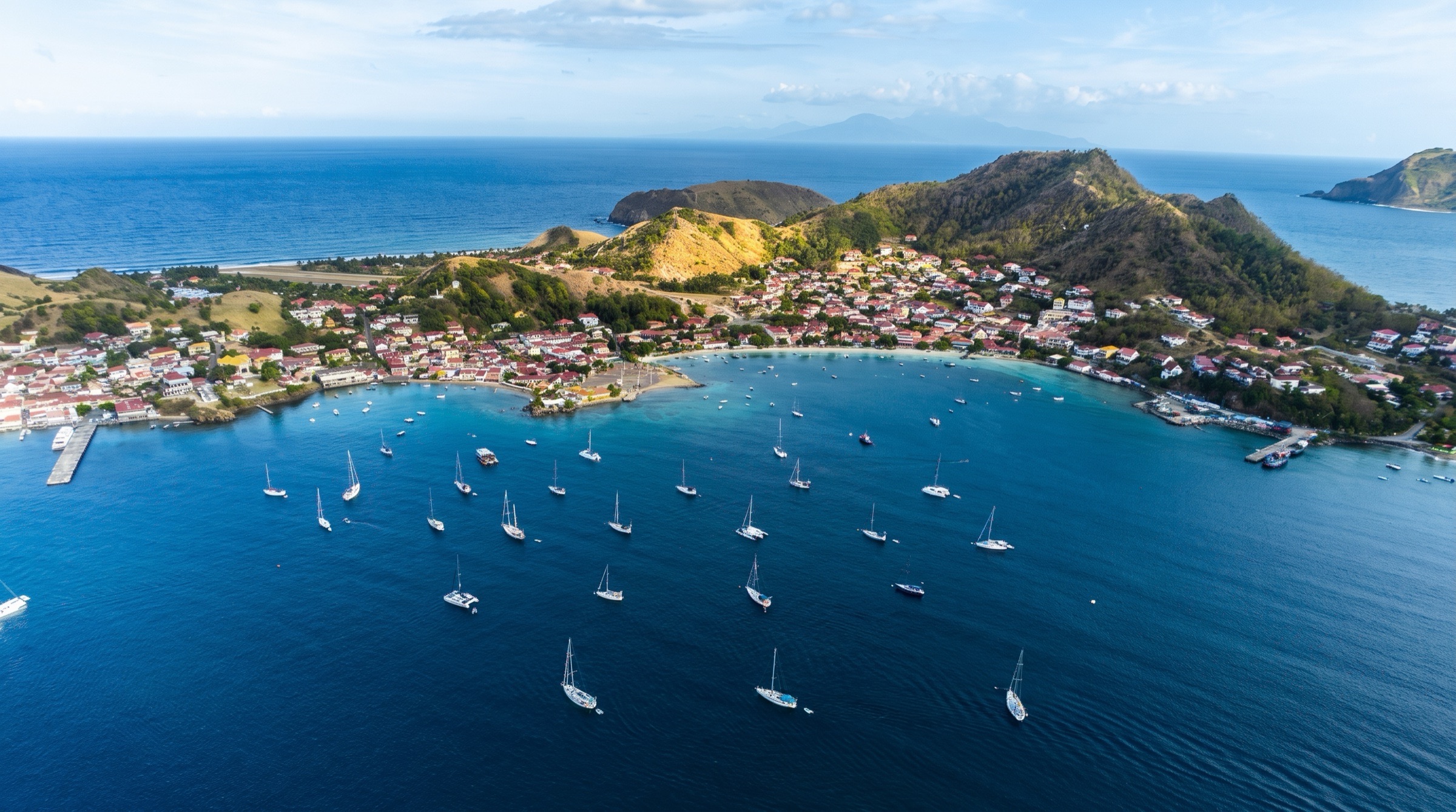
Guadeloupe's butterfly-shaped main island has Pigeon Island, a Cousteau reserve for diving, while Les Saintes offers a tiny French harbor in a volcanic bay. Dominica, to the south, is the wild island, with rainforest river trips and hot springs. Winds are strong and you cross open channels.
Best months
Difficulty
ModerateStrong trades, gusty leeward coasts and fishing floats in open channels.
Conditions
Easterly trades of 15-25 knots, with strong gusts and calms in the lee of Guadeloupe, Dominica and Les Saintes. The channels between islands are rough. Unlit fish pots are common. Winter north swells affect west coast anchorages. Hurricane season is June to November.
Area guide
Leeward Islands
Anguilla (UK) · Saint Martin (France) · Sint Maarten (Netherlands) · Saint Barthelemy (France) · Saba (Netherlands) · Sint Eustatius (Netherlands) · Saint Kitts and Nevis · Antigua and Barbuda · Montserrat (UK) · Guadeloupe (France) · Dominica
The Leeward Islands are the northern arc of the Lesser Antilles, a chain of short day-hops from Anguilla south to Guadeloupe and its dependencies (Les Saintes, Marie-Galante, La Desirade, Petite Terre); Dominica, historically counted as a Leeward and moved to the Windward administration in 1940, is included here as the natural southern end of a Leewards cruise. Sovereignty is a patchwork - British (Anguilla, Montserrat), French (Saint-Martin, St Barthelemy, Guadeloupe), Dutch (Sint Maarten, Saba, Statia), and independent (St Kitts & Nevis, Antigua & Barbuda, Dominica) - so a two-week cruise can mean four or five clearances, currencies and languages. The islands fall into two characters: low, dry limestone islands ringed by reef and white sand (Anguilla, Barbuda, Antigua's coast, Grande-Terre, Marie-Galante, Petite Terre), and steep volcanic islands with rainforest, hot springs and deep-water lee anchorages (Saba, Statia, St Kitts, Nevis, Montserrat - still active - Basse-Terre and Dominica). Highlights for sailors: the Georgian dockyard and hurricane holes of English Harbour, reef-sheltered Nonsuch Bay and North Sound, Barbuda's empty pink beaches and frigatebird colony, the St Martin lagoon (the region's biggest repair and chandlery hub), St Barth's reserve anchorages, Saba's pinnacle diving, the Cousteau reserve, Les Saintes, and Dominica's river tours, whales and Boiling Lake. Passages between islands are typically 10-50 nm across open trade-wind channels.
Top of the list
- 1Nelson's Dockyard MarinaThe world's only continuously working Georgian dockyard (UNESCO World Heritage) - tie up or anchor in English Harbour among restored 18th-century stone buildings, the Leewards' yachting capital.
- 2Shirley Heights LookoutHike up from Galleon Beach for the classic view over English and Falmouth Harbours; the Sunday-evening steel band and sunset party is a cruiser rite.
- 3Green Island West Beach AnchorageReef-protected turquoise water behind Green Island at the mouth of Nonsuch Bay - trade-wind cooling with no swell, kiting and reef snorkelling off the stern.
- 4Great Bird Island AnchorageNorth Sound's reef-sheltered islets: snorkel the shallows and walk the trail of the Antiguan racer, one of the world's rarest snakes.
- 5Codrington Lagoon Frigatebird SanctuaryReported as the largest magnificent frigatebird colony in the world (Man of War Island); breeding season roughly September to March or April.
- 6Cocoa Point AnchorageBarbuda's south-coast sand anchorage - miles of empty white-and-pink beach, turtles, and the feeling of the Caribbean before development.
- 7Princess Diana BeachBarbuda's famous pink-sand strand; land the dinghy and walk for miles.
- 8Ilet Pinel AnchorageA short, reef-sheltered hop from Cul-de-Sac on St Martin's NE coast: beach restaurants, a marked snorkel trail and Orient Bay next door.
- 9Ile Tintamarre MooringsUninhabited nature-reserve island off St Martin with a long white beach and the Tugboat wreck dive; evening moorings must be requested days ahead.
- 10Road Bay Anchorage (Sandy Ground)Anguilla's sole port of entry and best overnight anchorage - beach bars on the sand, the salt pond behind, and the jump-off for Sandy Island and Prickly Pear.
- 11Prickly Pear Cays Day MooringsAnguilla marine-park cays with startling water clarity, a beach restaurant and reef snorkelling; day-use moorings under the cruising permit.
- 12Anse du Colombier MooringsSt Barth's road-free bay inside the marine reserve: turtles under the boat, a hike over to Flamands, and sunset over Ile Fourchue.
- 13Gustavia HarbourThe jet-set harbour of St Barth - superyachts, duty-free Swedish-era town, Le Select, and the base for the island's regattas.
- 14Ile Fourchue MooringsA horseshoe-shaped uninhabited reserve island NW of St Barth with clear water, goats and a wild hike to the ridge.
- 15Ladder Bay MooringsSaba's dramatic lee-side moorings beneath 800 hand-cut steps of The Ladder - jump-off for world-class pinnacle diving in the Saba Marine Park.
- 16Mount Scenery TrailClimb from Windwardside through cloud forest to the highest point in the Kingdom of the Netherlands (887 m).
- 17The Quill Volcano TrailHike Statia's dormant volcano and descend into the rainforest crater; pairs with the historic wreck dives off Oranjestad.
- 18Brimstone Hill FortressUNESCO-listed British fortress on St Kitts's west coast with views to Statia and Saba.
- 19Pinney's Beach AnchorageNevis's long palm-lined beach on NASPA moorings beneath the cloud-capped peak, with beach bars and Charlestown nearby.
- 20Pigeon Islands (Reserve Cousteau)Guadeloupe's flagship snorkel and dive site off Malendure - the Cousteau statue, turtles and dense reef fish inside the national park.
- 21Deshaies Anchorage & MooringsThe classic landfall bay on Basse-Terre's NW corner after the Antigua crossing: clearance, creole restaurants and the botanical garden.
- 22Petite Terre MooringsRemote nature-reserve islets east of Guadeloupe: lemon sharks and turtles in the lagoon and hundreds of iguanas ashore; moorings must be booked.
- 23Terre-de-Haut Mooring Field (Les Saintes)One of the most beautiful bays in the Caribbean - colourful French village, Fort Napoleon above, and a lively waterfront.
- 24Anse Canot (Marie-Galante)Calm, clear sand anchorage on 'the island of a hundred windmills', base for the rum distilleries and wild Atlantic cliffs.
- 25Indian River TourRowed (no engines) up a mangrove-and-bloodwood river from Portsmouth with a PAYS guide - one of the Caribbean's essential excursions.
- 26Champagne ReefSnorkel through curtains of volcanic bubbles rising from the seabed in Dominica's Soufriere-Scotts Head Marine Reserve.
- 27Sperm Whale Watching (Dominica)Dominica hosts a resident sperm whale population year-round, now protected by a dedicated reserve off the west coast.
- 28Montserrat Volcano ObservatoryWatch the Soufriere Hills volcano and the buried capital of Plymouth from the observatory - a stop unlike any other in the Caribbean.
When to go
Main season December to May, when the easterly trades are established and the region is outside hurricane season (several country guides give December-May as the best sailing window). December-March brings the 'Christmas winds' - reinforced trades often 20-25 kn with bigger seas in the inter-island channels; April-May is usually lighter and calmer, and is regatta season (Antigua Sailing Week, Les Voiles de Saint-Barth). Northerly 'ground swells' from North Atlantic storms between roughly November and April can make north- and west-facing anchorages (Road Bay, Marigot, Anse Marcel, Gustavia, Little Bay Montserrat, Deshaies) rolly or untenable for a day or two. June to November is hurricane season; most cruisers leave for Grenada/Trinidad or lay up in a hurricane-rated yard, though summer can be pleasant between systems.
Weather and hazards
Trade winds blow mostly from the east to northeast (ENE-ESE) at 12-20 kn, frequently 20-25 kn in winter reinforcements; expect accelerated wind and steep seas in the channels between high islands (Guadeloupe Channel, The Narrows, Dominica Passage) and strong, gusty katabatic squalls and calms in the lee of the high volcanic islands - gusts to around 40 kn have been reported off Dominica's west coast. Squalls with brief heavy rain are common. Reef hazards around the low islands (Anguilla's reefs, Barbuda's Palaster/Cocoa Point reefs, Antigua's North Sound and Nonsuch Bay, Grande-Terre's Grand Cul-de-Sac Marin) demand good light and eyeball navigation; Barbuda is low and poorly charted - approach in daylight. Unlit fish-trap floats are common, especially off Guadeloupe and Dominica. Northerly ground swell (winter) can close anchorages and make dinghy landings dangerous. Sargassum seaweed influxes (mostly spring-summer) foul windward beaches, intakes and props. Montserrat's Soufriere Hills volcano remains under monitoring with a maritime exclusion zone along the south and east coasts; ash can fall on boats downwind. Ferry and fast-boat wakes in Marigot, Philipsburg and Les Saintes. Simpson Bay Lagoon water quality is poor. Petty theft and dinghy theft occur in busier harbours - lock dinghies and outboards.
Hurricane season
Atlantic hurricane season runs officially 1 June to 30 November, peaking late August to September (midpoint about 10 September). The Leewards sit in the main development region and have been hit hard - Hurricanes Irma and Maria (September 2017) devastated Barbuda, St Martin, St Barth, Anguilla and Dominica. Insurers commonly require yachts to be south of a named latitude or in an approved hurricane plan. Traditional storm shelters include Simpson Bay Lagoon (St Martin - crowded and badly damaged in Irma), English Harbour and Falmouth Harbour, Jolly Harbour and Parham/North Sound (Antigua), and the mangroves of the Riviere Salee and Grand Cul-de-Sac Marin (Guadeloupe); many owners instead haul out in hurricane-rated yards (St Martin, Antigua, Guadeloupe) with tie-downs or cradles.
Entry and clearance
Every jurisdiction requires its own clearance, including between French territories (Saint-Martin, St Barth and Guadeloupe each require clearing out before sailing to another). Pre-arrival: SailClear (and/or eSeaClear in Antigua - use only one) is used by Antigua & Barbuda, St Kitts & Nevis, Anguilla, Montserrat and Dominica; SailClear introduced a US$25 annual subscription from 1 May 2024. St Kitts & Nevis also requires CARICOM eAPIS for the vessel and the KN travel form for crew; Dominica added an optional online ED card in 2025. French islands (Saint-Martin, St Barth, Guadeloupe, Les Saintes) moved to an online declaration (demarches-simplifiees.fr) from 1 September 2024, with clearance terminals also at many chandleries and marina offices (e.g. Island Water World and Ile Marine on Saint-Martin, Marina Bas-du-Fort, Les Saintes, Riviere-Sens; Deshaies arrangements changed after Le Pelican closed - check locally); St Barth uses the Port de Gustavia's own clearance site. Ports of entry: Anguilla - Road Bay only. Sint Maarten - Simpson Bay (SLAC office by the bridge) and Philipsburg/Great Bay. Saint-Martin - Marigot and Anse Marcel (plus terminals). St Barth - Gustavia. Saba - Fort Bay. Statia - Oranjestad (Gallows Bay); clear-out up to 24 hours before leaving. St Kitts - Basseterre (Port Zante/Deepwater Port) and Christophe Harbour; Nevis - Charlestown (moving between St Kitts and Nevis does not require re-clearance). Antigua - English Harbour/Falmouth (Nelson's Dockyard), Jolly Harbour, St John's and North Sound; Barbuda - Codrington (clear in Antigua for the nation; Codrington handles check-in/out). Montserrat - Little Bay only (in-and-out together for stays of 72 hours or less; free coastal cruising authorisation needed even to land on the Little Bay beach). Guadeloupe - Pointe-a-Pitre/Bas-du-Fort, Deshaies, Riviere-Sens, Les Saintes and others listed by French customs. Dominica - Portsmouth and Roseau; in-and-out together for stays up to two weeks. Clear within 24 hours of arrival. Most countries give visitors up to 90 days; check visa rules per nationality (French and Dutch territories follow their own national rules and are outside Schengen).
Permits and fees
Fees change often - verify locally. Anguilla: a cruising permit (in EC$, priced by tonnage and by day/week/month) is required to go anywhere except Road Bay, including by dinghy; it includes the day-use marine-park moorings (about 6am-7pm) at Sandy Island, Prickly Pear, Little Bay and Shoal Bay East, and anchoring is prohibited or restricted at those sites and Dog Island. Sint Maarten: Simpson Bay bridge fees by length paid at SLAC before entry (Noonsite 2025: 9-12 m US$7, 12-15 m $21, 15-18 m $42, 18-22 m $120) plus harbour/lagoon fees. Saint-Martin: Port de Marigot anchorage/mooring fees (0-12 m EUR9.20/day, EUR55/week; 12.1-15 m EUR11.96/day; >15 m EUR15/day; +4% TGCA; multihulls +50%) and clearance EUR10.50 for visitors; Saint-Martin Nature Reserve fees for Tintamarre/Pinel area moorings. St Barth: Gustavia harbour and reserve fees by length and zone (cruisers reported about EUR35-40/night in the outer harbour, 2024); Colombier and Fourchue reserve moorings. Saba: marine park yacht fee US$3 per person (per week) plus nature fee US$1 per person per night; harbour fee typically US$20-40 by tonnage (Noonsite 2023); yellow visitor moorings first-come, first-served, max 20 m/50 t, 7 days. Statia: marine park fee US$10/night, max US$30/week, paid at the harbour office on check-in. St Kitts & Nevis: customs and port dues; NASPA mooring fees on Nevis by size class (vessels must pick up an assigned mooring on the west coast and obtain a coastal permit before moving). Antigua & Barbuda: clearance plus cruising permit (cruisers report EC$85 at Jolly Harbour) and Nelson's Dockyard National Park fees in English and Falmouth Harbours. Montserrat: coastal cruising authorisation is free. Guadeloupe: no cruising permit; mooring fees (e.g. Les Saintes about EUR13-18/night, Deshaies about EUR25/night under 14 m, Petite Terre moorings by reservation). Dominica: small customs fees (Roseau EC$10-75 depending on size and crew); PAYS/Roseau mooring services charge per night.
Tides and currents
Tides are small - typically under about 0.3-0.5 m (1-1.5 ft) range - and mixed/semidiurnal, so charted depths can be used with little allowance; wind and barometric setup can matter as much. Tidal heights for French ports are published by SHOM (maree.shom.fr: Pointe-a-Pitre, Deshaies, Marigot, Gustavia); NOAA/UKHO predictions cover English Harbour and St John's. The westward-setting Caribbean current (Antilles/Guiana current branch) typically runs 0.5-1.5 kn through the channels, setting boats west of the rhumb line, and accelerates around headlands and in The Narrows and Guadeloupe Channel. Ravine Paul Thomas and other Basse-Terre anchorages note local tidal currents. In Simpson Bay Lagoon and Saint-Martin's Oyster Pond the entrances are affected by swell more than tide.
Money
Eastern Caribbean dollar (XCD, EC$; pegged at about EC$2.70 = US$1) in Anguilla, St Kitts & Nevis, Antigua & Barbuda, Montserrat and Dominica - US dollars widely accepted but change often given in EC$. Euro (EUR) in Saint-Martin, St Barthelemy and Guadeloupe (incl. Les Saintes, Marie-Galante). Sint Maarten uses the Caribbean guilder (which replaced the Netherlands Antillean guilder in 2025) with US dollars used almost universally. Saba and Sint Eustatius use the US dollar. Cards accepted in main towns and marinas; carry cash for small islands (Barbuda, Saba, Statia, Montserrat, Les Saintes, Marie-Galante) and for some customs offices (Nevis fees cash; Jolly Harbour customs reported not to take cards).
Radio and phones
VHF 16 for calling and distress throughout. Specific channels reported: Simpson Bay bridge - request openings on VHF 12; Port de Marigot VHF 16; Gustavia Harbour Master VHF 16; Saba Harbour Master VHF 16; Statia Seaport VHF 16 (STENAPA marine park VHF 17/16); Nevis NASPA VHF 16 (call on approach to be assigned a mooring); Montserrat Port Authority VHF 16 monitored 24 hours; Dominica PAYS VHF 16 (WhatsApp often faster). French waters are covered by CROSS Antilles-Guyane (Martinique) for search and rescue; general emergency numbers: 911 in Antigua & Barbuda and other English-speaking islands, 112/15/17/18 in the French islands. Mobile coverage is generally good; Digicel and Flow operate across the English-speaking islands, Orange and others on the French islands - roaming charges change as you cross borders. Morning cruiser nets operate in St Martin and Antigua (verify current channels and times locally).
Charter bases
- Marina Fort Louis (Marigot, St Martin)Marigot, French side of St Martin - about 30-40 minutes by road from Princess Juliana airport; Anguilla and St Barth are day-sails awayThe Moorings (moved from Oyster Pond to Marigot after Hurricane Irma), Sunsail (Marina Fort Louis per 2025 fleet listings)
- Simpson Bay Lagoon & Anse Marcel (St Martin)Dutch and French sides of St MartinDream Yacht Charter and independent operators (verify current base locations)
- Jolly Harbour Marina (Antigua)West coast of Antigua, Bolans - the island's main bareboat baseDream Yacht Charter (Jolly Harbour Marina, The Boat Yard, Dock D), Other independent bareboat fleets (verify current)
- English Harbour & Falmouth Harbour (Antigua)South coast of Antigua - crewed and superyacht charter hub; Antigua Charter Yacht Show held here each DecemberCrewed charter yachts and brokers
- Marina Bas-du-Fort (Pointe-a-Pitre, Guadeloupe)Between Pointe-a-Pitre and Le Gosier at the head of the Petit Cul-de-Sac Marin, under 4 miles from PTP airport - home to almost the entire Guadeloupe charter fleetDream Yacht Charter (1 Porte de la Marina; 8am-6pm, gate closed 6pm-7am and weekends), Filovent and other French operators, Alternative Sailing (announced a Guadeloupe base for end of 2024; verify)
Getting there
- Princess Juliana International Airport (Sint Maarten) — SXMThe region's main long-haul hub (North America and Europe). Short hops from here to Anguilla, St Barth, Saba, Statia, Nevis and Antigua; ferries run to Anguilla (Blowing Point), St Barth and Saba.
- L'Esperance Airport (Grand Case, Saint-Martin) — SFGRegional flights on the French side, including to Guadeloupe and St Barth.
- V. C. Bird International Airport (Antigua) — ANUAbout 8 km NE of St John's. Direct from the UK, US and Canada; LIAT-successor and regional carriers to the other Leewards. Ferry/flights to Barbuda.
- Pointe-a-Pitre International Airport (Guadeloupe) — PTP2.4 km NNE of Pointe-a-Pitre; daily flights from Paris Orly (Air Caraibes, Corsair) and Paris CDG (Air France). Ferries to Les Saintes, Marie-Galante and Dominica.
- Robert L. Bradshaw International Airport (St Kitts) — SKBNE of Basseterre; US and regional flights. Ferries to Nevis.
- Clayton J. Lloyd International Airport (Anguilla) — AXAIn The Valley; regional flights (often via SXM or San Juan).
- Gustaf III Airport (St Barthelemy) — SBH646 m runway with a famously steep approach; small aircraft only from SXM, Guadeloupe and other nearby islands.
- Juancho E. Yrausquin Airport (Saba) — SABOne of the world's shortest commercial runways; flights from SXM.
- F. D. Roosevelt Airport (Sint Eustatius) — EUXFlights from SXM.
- John A. Osborne Airport (Montserrat) — MNISmall aircraft from Antigua; ferry from Antigua also runs.
- Douglas-Charles Airport (Dominica) — DOMNE coast; about 45 minutes by road to Portsmouth and 1 hour to Roseau; direct from Miami and Newark. Canefield (DCF) near Roseau handles small aircraft; a new Dominica International Airport at Wesley is under construction (expected 2026).
Charts and guides
- Chris Doyle, Cruising Guide to the Leeward Islands (Cruising Guide Publications; current edition) - the standard Anguilla-to-Dominica guide
- Bruce Van Sant / Don Street historic guides; Street's Transatlantic Crossing Guide and Imray-Iolaire charts
- Imray-Iolaire charts A-series (e.g. A24 Anguilla/St Martin/St Barthelemy; A25 Montserrat-Antigua-Guadeloupe region; A26-A30 Guadeloupe/Dominica) - verify current numbering
- SHOM charts for the French islands (Saint-Martin, Saint-Barthelemy, Guadeloupe and dependencies)
- UKHO Admiralty charts for Anguilla, Antigua & Barbuda, St Kitts & Nevis, Montserrat, Dominica
- Antigua & Barbuda Marine Guide (antiguamarineguide.com) - annual marine directory
- Noonsite country pages and noforeignland community guides for current clearance and fees
- Navionics / Garmin ActiveCaptain community data for anchorage reviews
Sample routes
- 7-day St Martin - Anguilla - St Barth loop from MarigotDay 1 · Marina Fort Louis → Road Bay Anchorage (Sandy Ground) · 8 nmClear out of Saint-Martin, short reach across the Anguilla Channel; clear in at Road Bay and get a cruising permit; sunset at the Road Bay beach bars. Distances approximate.Day 2 · Road Bay Anchorage (Sandy Ground) → Prickly Pear Cays Day Moorings · 6 nmMorning snorkel at Sandy Island en route; lunch and reef snorkel at Prickly Pear; return to Road Bay to anchor overnight (marine-park moorings are day-use only).Day 3 · Road Bay Anchorage (Sandy Ground) → Grand Case Anchorage · 12 nmClear out of Anguilla; back to Saint-Martin's north coast; dinner at the Grand Case lolos.Day 4 · Grand Case Anchorage → Ilet Pinel Anchorage · 8 nmRound the north tip past Anse Marcel; snorkel the Pinel trail; optional day stop at Tintamarre (evening moorings need advance request).Day 5 · Ilet Pinel Anchorage → Anse du Colombier Moorings · 15 nmClear out, reach SE to St Barth; turtles at Colombier; clear in at Gustavia (online) and hike the Colombier trail.Day 6 · Anse du Colombier Moorings → Ile Fourchue Moorings · 4 nmMorning in Gustavia (Le Select, Fort Karl); afternoon swim and ridge hike at Fourchue.Day 7 · Ile Fourchue Moorings → Marina Fort Louis · 16 nmClear out of St Barth; downwind return to Marigot along St Martin's south coast or via Simpson Bay.
- 7-day Antigua circumnavigation from Jolly HarbourDay 1 · Jolly Harbour Marina → Deep Bay Anchorage · 6 nmShakedown sail north; snorkel the Andes wreck in the bay and walk up to Fort Barrington. Distances approximate.Day 2 · Deep Bay Anchorage → Great Bird Island Anchorage · 14 nmRound the NW tip and enter North Sound via the Boon/Diamond channels in good light; snorkel and walk the Antiguan racer trail.Day 3 · Great Bird Island Anchorage → Green Island West Beach Anchorage · 12 nmOutside the reefs down the east coast, enter Nonsuch Bay by the Green Island channel; kite, paddle and snorkel the reef.Day 4 · Green Island West Beach Anchorage → Nelson's Dockyard Marina · 10 nmBeat or motor-sail south to English Harbour; afternoon in Nelson's Dockyard and the Dockyard Museum.Day 5 · Nelson's Dockyard Marina → Falmouth Harbour Anchorage · 2 nmHike the Middle Ground trail to the Pillars of Hercules and Shirley Heights; Sunday-evening Shirley Heights party.Day 6 · Falmouth Harbour Anchorage → Carlisle Bay Anchorage (Antigua) · 6 nmWest along the south coast past Rendezvous Bay; quiet bay below the rainforest - optional Mount Obama hike.Day 7 · Carlisle Bay Anchorage (Antigua) → Jolly Harbour Marina · 9 nmLunch stop at Cades Reef (inside passage in good light) then back to base.
- 10-day Antigua - Barbuda - Montserrat - Nevis - St Kitts one-wayDay 1 · Jolly Harbour Marina → Dickenson Bay Anchorage · 8 nmProvision and position on the north coast for the Barbuda run. Distances approximate.Day 2 · Dickenson Bay Anchorage → Low Bay Anchorage · 28 nmOpen-water reach north; make landfall in good light - Barbuda is low and reef-strewn.Day 3 · Low Bay Anchorage → Low Bay Anchorage · 0 nmGuided water-taxi trip across Codrington Lagoon to the frigatebird colony; walk Eleven Mile Beach.Day 4 · Low Bay Anchorage → Cocoa Point Anchorage · 10 nmRound Palmetto Point to the south coast; Princess Diana Beach; snorkel Spanish Point by dinghy.Day 5 · Cocoa Point Anchorage → Nelson's Dockyard Marina · 32 nmBack to Antigua's south coast; clear out for Montserrat.Day 6 · Nelson's Dockyard Marina → Little Bay Anchorage (Montserrat) · 28 nmClear in at Little Bay, get coastal authorisation; afternoon tour to the Volcano Observatory and Plymouth viewpoints.Day 7 · Little Bay Anchorage (Montserrat) → Pinney's Beach Anchorage · 33 nmPass Redonda (view only); clear in at Charlestown and take an assigned NASPA mooring.Day 8 · Pinney's Beach Anchorage → Pinney's Beach Anchorage · 0 nmHike Nevis Peak or visit Charlestown, the Hamilton museum and Bath hot springs.Day 9 · Pinney's Beach Anchorage → White House Bay Anchorage · 8 nmThrough The Narrows past Booby Island to St Kitts's SE peninsula; Cockleshell Bay beach bars.Day 10 · White House Bay Anchorage → Port Zante Marina · 6 nmInto Basseterre; Brimstone Hill Fortress by taxi; end of trip.
- 14-day Guadeloupe - Les Saintes - Marie-Galante - Dominica from Bas-du-FortDay 1 · Marina Bas-du-Fort → Ilet du Gosier Anchorage · 3 nmShort shakedown; swim off the islet and its lighthouse. Distances approximate.Day 2 · Ilet du Gosier Anchorage → Petite Terre Moorings · 26 nmPre-booked reserve mooring; transit the pass in good light; snorkel with lemon sharks and turtles; iguanas ashore.Day 3 · Petite Terre Moorings → Saint-Louis Anchorage (Marie-Galante) · 21 nmReach SW to Marie-Galante; hire a car for the distilleries and Gueule Grand Gouffre.Day 4 · Saint-Louis Anchorage (Marie-Galante) → Anse Canot (Marie-Galante) · 3 nmLazy beach day in clear water.Day 5 · Anse Canot (Marie-Galante) → Terre-de-Haut Mooring Field (Les Saintes) · 18 nmPick up a buoy off the Bourg; walk up to Fort Napoleon; tourment d'amour pastries.Day 6 · Terre-de-Haut Mooring Field (Les Saintes) → Pain de Sucre Moorings (Les Saintes) · 2 nmSnorkel the Pain de Sucre; hike Le Chameau; clear out for Dominica at Les Saintes.Day 7 · Pain de Sucre Moorings (Les Saintes) → Prince Rupert Bay Anchorage (Portsmouth) · 22 nmCross the Dominica Passage; PAYS mooring and clearance; Cabrits and Fort Shirley.Day 8 · Prince Rupert Bay Anchorage (Portsmouth) → Prince Rupert Bay Anchorage (Portsmouth) · 0 nmEarly-morning Indian River tour; Sunday PAYS barbecue if it falls right.Day 9 · Prince Rupert Bay Anchorage (Portsmouth) → Roseau Mooring Field (Castle Comfort to Loubiere) · 22 nmDown the lee coast (watch for gusts off the valleys); moorings via local yacht services.Day 10 · Roseau Mooring Field (Castle Comfort to Loubiere) → Roseau Mooring Field (Castle Comfort to Loubiere) · 0 nmChampagne Reef snorkel and Scotts Head; whale-watching trip; Trafalgar Falls or Titou Gorge.Day 11 · Roseau Mooring Field (Castle Comfort to Loubiere) → Terre-de-Haut Mooring Field (Les Saintes) · 38 nmClear out of Dominica (in-and-out together allowed); close-hauled return north to Les Saintes and clear back in.Day 12 · Terre-de-Haut Mooring Field (Les Saintes) → Malendure Anchorage · 20 nmAcross the Canal des Saintes and up the Basse-Terre lee coast; Pigeon Islands (Reserve Cousteau) snorkel.Day 13 · Malendure Anchorage → Deshaies Anchorage & Moorings · 10 nmBotanical garden and Riviere Deshaies; creole dinner.Day 14 · Deshaies Anchorage & Moorings → Marina Bas-du-Fort · 45 nmLong final leg back south around Basse-Terre's lee and east to Pointe-a-Pitre (or plan a one-way return from Riviere-Sens).
Places in Leeward Islands
- A&F Sails (Nelson's Dockyard)Service · Antigua
- ACE Mega Center (Cole Bay)Service · Sint Maarten (Dutch side)
- AD Nautic Pointe-a-Pitre (Bas-du-Fort)Service · Grande-Terre
- AIR Studios (Montserrat)Landmark · Montserrat
- Al Porto (Jolly Harbour)Eat · Antigua
- Alexander Hamilton House MuseumLandmark · Nevis
- Alexandra Hospital (Nevis)Service · Nevis
- Alliouagana Festival of the WordEvent · Montserrat
- AMC Supermarket (Gustavia)Stores · St Barthelemy
- American Gourmet (Gustavia Minimarket)Stores · St Barthelemy
- Anchor Point (Statia)Dive · Sint Eustatius (Statia)
- Andes Wreck (Deep Bay)Snorkel · Antigua
- Anguilla Cruising Permit & Marine Park Day MooringsPermit · Anguilla
- Anguilla Customs & Immigration, Road Bay (Port of Entry)Permit · Anguilla
- Anguilla Day Boat Race (Sandy Ground)Event · Anguilla
- Anguilla RegattaEvent · Anguilla
- Anguilla Summer Festival Boat RacingEvent · Anguilla
- Anguillita Island DiveDive · Anguillita
- Anse a Dos Beach (Terre-de-Bas)Beach · Terre-de-Bas
- Anse a la Barque AnchorageAnchorage · Basse-Terre
- Anse Canot (Marie-Galante)Anchorage · Marie-Galante
- Anse Caraibe AnchorageAnchorage · Basse-Terre
- Anse Champagne (Saint-Francois)Beach · Grande-Terre
- Anse CrawenBeach · Terre-de-Haut
- Anse Crawen SnorkelSnorkel · Terre-de-Haut
- Anse de Corossol AnchorageAnchorage · St Barthelemy
- Anse de Grande SalineBeach · St Barthelemy
- Anse de Grande Saline AnchorageAnchorage · St Barthelemy
- Anse de LorientBeach · St Barthelemy
- Anse de Marigot & Petit Cul-de-SacSnorkel · St Barthelemy
- Anse de Public AnchorageAnchorage · St Barthelemy
- Anse des Flamands AnchorageAnchorage · St Barthelemy
- Anse du Colombier BeachBeach · St Barthelemy
- Anse du Colombier MooringsAnchorage · St Barthelemy
- Anse du Figuier & Anse Rodrigue BeachesBeach · Terre-de-Haut
- Anse du Gouverneur AnchorageAnchorage · St Barthelemy
- Anse Feuillard & East Coast TrailHike · Marie-Galante
- Anse Marcel AnchorageAnchorage · St Martin (French side)
- Anse Marcel Beach RestaurantEat · St Martin (French side)
- Anse Marcel MarinaMarina · St Martin (French side)
- Antigua CarnivalEvent · Antigua
- Antigua Charter Yacht ShowEvent · Antigua
- Antigua Classic Yacht RegattaEvent · Antigua
- Antigua Commercial Bank & ATMs (Barbuda)Service · Barbuda
- Antigua Sailing WeekEvent · Antigua
- Antigua Scuba School (Bodog Beach Club)Dive · Antigua
- Antigua SlipwayService · Antigua
- Antigua Slipway Fuel Dock (English Harbour)Service · Antigua
- Antigua Yacht ClubBar · Antigua
- Antigua Yacht Club MarinaMarina · Antigua
- Aquarium de la GuadeloupeLandmark · Grande-Terre
- Arob@se Cafe (Saint-Francois)Bar · Grande-Terre
- ArtCafe BarbudaEat · Barbuda
- Au Bon Vivre (Terre-de-Haut)Eat · Terre-de-Haut
- Au Martin Pecheur (Jarry Fishing Shop)Service · Grande-Terre
- Au Regal (Corossol)Eat · St Barthelemy
- August Thursday Boat Race (Meads Bay)Event · Anguilla
- Augustin Fresnel II Wreck (Bouillante)Dive · Basse-Terre
- AXA Yacht Services (Yacht Agent)Service · Anguilla
- Ayoun Beach Bar (Grande Anse, Deshaies)Bar · Basse-Terre
- Baie Blanche Beach (Tintamarre)Beach · Ile Tintamarre
- Baie de PompierreBeach · Terre-de-Haut
- Baie RougeBeach · St Martin (French side)
- Baie-Mahault Leprosarium Ruins (La Desirade)Landmark · La Desirade
- Baille-Argent Fishing Port & Fish Market (Pointe-Noire)Stores · Basse-Terre
- Ballast Bay AnchorageAnchorage · St Kitts
- Bar-B's Restaurant & Bar (Antigua Yacht Club)Eat · Antigua
- Bar'bord (Cheval Blanc, Flamands)Eat · St Barthelemy
- Barbuda Fishing & LobsterFishing · Barbuda
- Barbuda Hillside View Bar & GrillEat · Barbuda
- Barbuda Hurricane SeasonSeasonal · Barbuda
- Barbuda Island Taxis & ToursTour · Barbuda
- Barbuda Kite & Wing-Foil SpotsWatersport · Barbuda
- Barbuda Marine Zoning (Blue Halo Regulations)Permit · Barbuda
- Barbuda Reef WrecksDive · Barbuda
- Barbuda Turf Club Horse RacingEvent · Barbuda
- Barbuda Wildlife (Deer & Tortoises)Wildlife · Barbuda
- Barnes BayBeach · Anguilla
- Barracuda ReefDive · Antigua
- Barrel House StatiaEat · Sint Eustatius (Statia)
- Barrel Stay Restaurant on the BeachEat · Anguilla
- Bas-du-Fort AnchorageAnchorage · Grande-Terre
- Bas-du-Fort Marina RestaurantsEat · Grande-Terre
- Bas-du-Fort Marina Village ShopsStores · Grande-Terre
- Basse-Terre Town MarketStores · Basse-Terre
- Basseterre AnchorageAnchorage · St Kitts
- Basseterre Customs & ImmigrationPermit · St Kitts
- Basseterre Public MarketStores · St Kitts
- Basseterre to Charlestown FerryService · St Kitts
- Bastille Day & Fete de Saint-BarthelemyEvent · St Barthelemy
- Batalie Beach MooringsAnchorage · Dominica
- Bath Hotel & Hot SpringsLandmark · Nevis
- Batibou BeachBeach · Dominica
- Beauport Pays de la CanneLandmark · Grande-Terre
- Best Buy Grocery (Charlestown)Stores · Nevis
- Betty's HopeLandmark · Antigua
- Big Fish (Coral Beach Club, Oyster Pond)Eat · Sint Maarten (Dutch side)
- Big Papa's Restaurant (Portsmouth)Eat · Dominica
- Big Rock Engineering Gas Station (Fort Bay)Service · Saba
- Big Rock MarketStores · Saba
- Big Spring Heritage SiteLandmark · Anguilla
- Bistronòm Père LabatEat · Marie-Galante
- BK Fuel Depot (River Road)Service · Barbuda
- Black RocksView · St Kitts
- Black Rocks Harbour (under construction)Landmark · Saba
- Blanchard's Beach ShackEat · Anguilla
- Bloody PointLandmark · St Kitts
- Blowing Point Ferry TerminalService · Anguilla
- Blue Bead HoleDive · Sint Eustatius (Statia)
- Boardwalk Cafe (Nats Kitchen)Eat · Sint Eustatius (Statia)
- Bobby's Marina (Philipsburg)Marina · Sint Maarten (Dutch side)
- Bodog Beach Club (formerly Castaways)Bar · Antigua
- Boggy Peak (Mount Obama)Hike · Antigua
- Boiling LakeHike · Dominica
- BonitoEat · St Barthelemy
- Booby High ShoalsDive · Booby Island
- Booby IslandWildlife · Booby Island
- Booby Island RegattaEvent · Nevis
- Booyard Yacht ServicesService · Barbuda
- Bottom Bean CafeEat · Saba
- Bouillante Hot SpringsLandmark · Basse-Terre
- Boulangerie-Patisserie Choisy (Gustavia)Stores · St Barthelemy
- Bourg des Saintes (Le Mouillage Village)Landmark · Terre-de-Haut
- Bourg des Saintes Waterfront RestaurantsEat · Terre-de-Haut
- Boven Dry Forest & Statia Morning GloryWildlife · Sint Eustatius (Statia)
- Boven National ParkHike · Sint Eustatius (Statia)
- Brades ProvisioningStores · Montserrat
- Bransby Point BatteryLandmark · Montserrat
- Breakwater Anchorage (Gallows Bay, Statia)Anchorage · Sint Eustatius (Statia)
- Bridled Quail-Dove & Quill Forest BirdsWildlife · Sint Eustatius (Statia)
- Brigadoon RestaurantEat · Saba
- Brimstone Hill FortressLandmark · St Kitts
- Brimstone Shallows & The RockDive · St Kitts
- Bubble Beach Spa (Soufriere)Beach · Dominica
- Budget Marine (Cole Bay)Service · Sint Maarten (Dutch side)
- Budget Marine (English Harbour)Service · Antigua
- Budget Marine (Jolly Harbour)Service · Antigua
- Budget Marine (St Kitts)Service · St Kitts
- Burton's Laundromat (Jolly Harbour)Service · Antigua
- Bush Bar (Indian River)Bar · Dominica
- Cabrits Dive CentreDive · Dominica
- Cabrits National Park & Fort ShirleyLandmark · Dominica
- Cabrits TrailsHike · Dominica
- Cades Bay MooringsAnchorage · Nevis
- Cades ReefSnorkel · Antigua
- CadisMarket (Marigot)Stores · St Martin (French side)
- Café de la Marine (Terre-de-Haut)Eat · Terre-de-Haut
- Cafe des Arts (Charlestown)Eat · Nevis
- Calabash FestivalEvent · Montserrat
- Cape Shirley Dive SiteDive · Antigua
- Capesterre Market & ShopsStores · Marie-Galante
- Capitainerie Showers, Toilets & Water (Port de Gustavia)Service · St Barthelemy
- Captain Oliver's Marina (Oyster Pond)Marina · St Martin (French side)
- Captain Oliver's Restaurant (Oyster Pond) - ClosedEat · St Martin (French side)
- Captain' Nautic (Bas-du-Fort)Service · Grande-Terre
- Captain's BayBeach · Anguilla
- Caraibes Docks ServicesService · Grande-Terre
- Carambola Beach ClubEat · St Kitts
- Caribana (Barbuda)Event · Barbuda
- Carlisle Bay Anchorage (Antigua)Anchorage · Antigua
- Carpenter Rock TrailHike · Antigua
- Carpenters Rock Dive SiteDive · Antigua
- Carr's Bay AnchorageAnchorage · Montserrat
- Carr's Bay BeachBeach · Montserrat
- Carr's Bay Shore DiveDive · Montserrat
- Carrefour (Cole Bay, behind Port de Plaisance)Stores · Sint Maarten (Dutch side)
- Casa Datcha (Le Gosier)Bar · Grande-Terre
- Cascade aux EcrevissesHike · Basse-Terre
- Castaways Beach Hotel (Mero)Eat · Dominica
- Catamaran MarinaMarina · Antigua
- Catherine's CafeEat · Antigua
- Caye Plate & Anse du Coq (Sentier des Falaises)Hike · Marie-Galante
- Caye VerteSnorkel · Caye Verte
- Cecilia's & Garden Grill (Dutchman's Bay)Eat · Antigua
- Cedar Tree Point AnchorageAnchorage · Barbuda
- Centre Hills & Oriole WalkwayHike · Montserrat
- Champagne ReefSnorkel · Dominica
- Charlestown (Nevis)Landmark · Nevis
- Charlestown Customs & Port Authority (Nevis)Permit · Nevis
- Charlestown MooringsAnchorage · Nevis
- Charlestown ProvisioningStores · Nevis
- Charlie Brown WreckDive · Sint Eustatius (Statia)
- Chateau MuratLandmark · Marie-Galante
- Chaudiere PoolHike · Dominica
- Chesterfield's (Dock Maarten Marina)Eat · Sint Maarten (Dutch side)
- Chez Dominique et Gratien (Sainte-Anne)Bar · Grande-Terre
- Chez Ernest (Deshaies)Eat · Basse-Terre
- Chez Henri (Saint-Louis)Eat · Marie-Galante
- Chez les Filles (Terre-de-Haut)Eat · Terre-de-Haut
- Christena WreckDive · St Kitts
- Christophe Harbour Customs & ImmigrationPermit · St Kitts
- Christophe Harbour Marina (Safe Harbor St Kitts)Marina · St Kitts
- CHU de GuadeloupeService · Grande-Terre
- Chutes du CarbetHike · Basse-Terre
- Clarence HouseLandmark · Antigua
- Cloggy's Cafe (Antigua Yacht Club)Eat · Antigua
- Coastal Cruising Authorisation (Montserrat)Permit · Montserrat
- Cockleshell / Banana Bay AnchorageAnchorage · St Kitts
- Cockleshell & Banana Bay Points SnorkelSnorkel · St Kitts
- Cockleshell BayBeach · St Kitts
- Coco Kafe (Bas-du-Fort)Eat · Grande-Terre
- Cocoa Point AnchorageAnchorage · Barbuda
- Coconuts Bar (Terre-de-Haut)Bar · Terre-de-Haut
- Codrington (Barbuda)Landmark · Barbuda
- Codrington Lagoon Fisheries WharfService · Barbuda
- Codrington Lagoon Frigatebird SanctuaryWildlife · Barbuda
- Codrington Lagoon National ParkPermit · Barbuda
- Codrington ProvisioningStores · Barbuda
- Codrington Village Eateries & BarsEat · Barbuda
- Codrington Village Heritage WalkLandmark · Barbuda
- Colombier TrailHike · St Barthelemy
- Colombier Turtle SnorkelWildlife · St Barthelemy
- Commerce WreckDive · Anguilla
- Coral Group Bay BeachBeach · Barbuda
- Coral Group Bay ReefsSnorkel · Barbuda
- Cost U Less & Carrefour (Bush Road)Stores · Sint Maarten (Dutch side)
- Cottle Church RuinsLandmark · Nevis
- Couleurs du Monde (Terre-de-Haut)Eat · Terre-de-Haut
- Cousteau Statue DiveDive · Ilets Pigeon
- Cove BayBeach · Anguilla
- Cove Bay (Saba)Beach · Saba
- Covent Garden & Dockside Supermarket (English Harbour)Stores · Antigua
- Cow and Calf ReefDive · Sint Maarten (Dutch side)
- Cow RocksSnorkel · Nevis
- Crab Hill Bay (Johnson's Point)Anchorage · Antigua
- Crab Hole Liquors & C.E. Bailey's Supermarket (Falmouth)Stores · Antigua
- Crater's Edge (Soufriere Bay)Dive · Dominica
- Crispeen Track & Elfin Forest TrailHike · Saba
- Crocus Bay AnchorageAnchorage · Anguilla
- Crooks CastleSnorkel · Sint Eustatius (Statia)
- Cudjoe Head FestivalEvent · Montserrat
- da'Vida Restaurant, Crocus BayEat · Anguilla
- Danglebens PinnaclesDive · Dominica
- Dantana Beach (La Feuillère)Bar · Marie-Galante
- Darby Sink CaveHike · Barbuda
- Dark CaveHike · Barbuda
- Dawn BeachBeach · Sint Maarten (Dutch side)
- Deep Bay AnchorageAnchorage · Antigua
- Deep Water Port Anchorage (Basseterre East)Anchorage · St Kitts
- Dennis Cocktail Bar & RestaurantEat · Antigua
- Deshaies Anchorage & MooringsAnchorage · Basse-Terre
- Deshaies Clearance OfficePermit · Basse-Terre
- Deshaies Coastline TrailHike · Basse-Terre
- Deshaies Fuel DockService · Basse-Terre
- Deshaies Village ProvisionsStores · Basse-Terre
- Deshaies Waterfront RestaurantsEat · Basse-Terre
- Destreland HypermarketStores · Grande-Terre
- Devil's BridgeLandmark · Antigua
- Diamond Rock (Saba)Dive · Saba
- Dickenson Bay AnchorageAnchorage · Antigua
- Dinghy Dock Bar (Oyster Pond)Bar · St Martin (French side)
- Dinghy Dock Bar (Simpson Bay)Bar · Sint Maarten (Dutch side)
- Distillerie BellevueTour · Marie-Galante
- Distillerie BielleTour · Marie-Galante
- Distillerie BologneTour · Basse-Terre
- Distillerie DamoiseauTour · Grande-Terre
- Distillerie Pere LabatTour · Marie-Galante
- Distillerie Reimonenq (Musee du Rhum)Tour · Basse-Terre
- Dive Nevis (Scuba Safaris), Oualie BeachService · Nevis
- Dive Operators (Castle Comfort / Soufriere)Service · Dominica
- DiveCarib (Falmouth Harbour)Dive · Antigua
- Dockyard MuseumLandmark · Antigua
- Dog Island (Anguilla)Wildlife · Dog Island
- Dominica Coast Guard BaseService · Dominica
- Dominica Marine CenterService · Dominica
- Dominica Online ED Card & SailClearPermit · Dominica
- Dominica Sperm Whale ReservePermit · Dominica
- Dominica-China Friendship Hospital (ex-Princess Margaret Hospital)Service · Dominica
- Double Wreck (Statia)Dive · Sint Eustatius (Statia)
- Douglas Bay MooringsAnchorage · Dominica
- Dow's Hill Interpretation CentreView · Antigua
- Dry Waterfall & Soldier Ghaut PetroglyphsHike · Montserrat
- Dutch Reformed Church RuinsLandmark · Sint Eustatius (Statia)
- Duverney's Supermarket (Portsmouth)Stores · Dominica
- Eco-Tourism Site Pass & Waitukubuli Trail PassPermit · Dominica
- Eddy's GhettoEat · St Barthelemy
- Eden Rock Beach Bar (Saint-Jean)Bar · St Barthelemy
- ElectecService · Sint Maarten (Dutch side)
- Electro Nautic (Jarry)Service · Grande-Terre
- Eleven Mile Beach (Low Bay)Beach · Barbuda
- Elvis' Beach BarBar · Anguilla
- Emerald PoolHike · Dominica
- English Harbour Anchorage (Freeman's Bay)Anchorage · Antigua
- English Harbour Customs, Immigration & Port AuthorityPermit · Antigua
- Enoch's Place (Marigot Market)Eat · St Martin (French side)
- Epicerie Bar Goubin (Ferry, Deshaies)Bar · Basse-Terre
- Epicerie de CorossolStores · St Barthelemy
- Epicurean Fine Foods (St John's)Stores · Antigua
- Etang de la Barriere Mangrove TrailHike · St Martin (French side)
- Explorer Island (Grand Ilet)Landmark · St Martin (French side)
- F. D. Roosevelt Airport (Statia)Service · Sint Eustatius (Statia)
- Fairway Mark It (Philipsburg)Stores · Sint Maarten (Dutch side)
- Falmouth Harbour AnchorageAnchorage · Antigua
- Falmouth Harbour MarinaMarina · Antigua
- Ferry Dive Site (Deshaies)Dive · Basse-Terre
- Festival de la Gastronomie de DeshaiesEvent · Basse-Terre
- Festival Del Mar (Island Harbour)Event · Anguilla
- Fete Communale de Terre-de-BasEvent · Terre-de-Bas
- Fete des Cuisinieres (Cooks' Festival)Event · Grande-Terre
- Fete Patronale de Terre-de-HautEvent · Terre-de-Haut
- Ffryes & Darkwood BeachesBeach · Antigua
- Ffryes Bay AnchorageAnchorage · Antigua
- Fishing Creek BeachBeach · Barbuda
- Five Islands HarbourAnchorage · Antigua
- FKG Marine RiggingService · Sint Maarten (Dutch side)
- Flat Point Tide PoolsHike · Saba
- Follow The Flag (Codrington)Stores · Barbuda
- Fond Curé Moorings (Terre-de-Haut)Anchorage · Terre-de-Haut
- Fort AmsterdamLandmark · Sint Maarten (Dutch side)
- Fort BarringtonHike · Antigua
- Fort Bay Harbour (Saba Port of Entry)Permit · Saba
- Fort Bay Harbour Bars & CafesBar · Saba
- Fort Bay MooringsAnchorage · Saba
- Fort Berkeley TrailHike · Antigua
- Fort Charles (Nevis)Landmark · Nevis
- Fort DelgresLandmark · Basse-Terre
- Fort Fleur d'Epee & Gosier Coast TrailHike · Grande-Terre
- Fort Gustave & Gustavia LighthouseView · St Barthelemy
- Fort JamesLandmark · Antigua
- Fort KarlView · St Barthelemy
- Fort Louis (Marigot)Landmark · St Martin (French side)
- Fort NapoleonLandmark · Terre-de-Haut
- Fort OranjeLandmark · Sint Eustatius (Statia)
- Fort Oscar (Gendarmerie)Landmark · St Barthelemy
- Fort Young Hotel Restaurants & Bars (Roseau)Eat · Dominica
- Fountain Cavern National ParkLandmark · Anguilla
- Fox's Bay BeachBeach · Montserrat
- Frank B. Armstrong PropaneService · St Kitts
- French Antilles Online ClearancePermit · Grande-Terre
- Freshwater Lake & Boeri LakeHike · Dominica
- Friar's Bay AnchorageAnchorage · St Martin (French side)
- Frigate Bay & Friars Bay ReefsDive · St Kitts
- Frigate Bay AnchorageAnchorage · St Kitts
- Frigate Bay Beach (South)Beach · St Kitts
- Frigatebird Breeding SeasonSeasonal · Barbuda
- Fuel & Water near Road BayService · Anguilla
- Fuel Docks (Simpson Bay Lagoon)Service · St Martin (French side)
- Galleon BeachBeach · Antigua
- Galley Island ReefSnorkel · Great Bird Island
- Gallows Bay Moorings (dive and private only)Anchorage · Sint Eustatius (Statia)
- Garibaldi Hill ViewpointView · Montserrat
- Geminga Boat YardService · St Martin (French side)
- George Jeffery's Tours (Codrington Lagoon Water Taxi)Tour · Barbuda
- Geraud's Patisserie (South Hill)Stores · Anguilla
- Golden Rock InnEat · Nevis
- Grand Case AnchorageAnchorage · St Martin (French side)
- Grand Case LolosEat · St Martin (French side)
- Grand Case Restaurant RowEat · St Martin (French side)
- Grand Cul-de-Sac Lagoon (St Barth)Watersport · St Barthelemy
- Grand Cul-de-Sac Marin Nature ReserveWildlife · Basse-Terre
- Grand Ilet Nature Reserve (Seabirds)Wildlife · Grand Ilet
- Grand Ilet SeamountDive · Grand Ilet
- Grand-Bourg Port (Marie-Galante)Anchorage · Marie-Galante
- Grand-Bourg Provisioning & ServicesStores · Marie-Galante
- Grande Anse (Deshaies)Beach · Basse-Terre
- Grande Anse (Terre-de-Haut)Beach · Terre-de-Haut
- Grande Anse Anchorage (Deshaies)Anchorage · Basse-Terre
- Grande Anse Beach (Terre-de-Bas)Beach · Terre-de-Bas
- Grandes Salines (Pointe des Chateaux)Beach · Grande-Terre
- Gravenor Bay AnchorageAnchorage · Barbuda
- Great Bay Anchorage (Philipsburg)Anchorage · Sint Maarten (Dutch side)
- Great Bay Customs & ImmigrationPermit · Sint Maarten (Dutch side)
- Great Bird Island AnchorageAnchorage · Great Bird Island
- Great Bird Island Trail & Antiguan RacerWildlife · Great Bird Island
- Great Fort George (Monk's Hill)Hike · Antigua
- Great Salt Pond (Southeast Peninsula)Wildlife · St Kitts
- Green Island & Windward Dive SitesDive · Saba
- Green Island West Beach AnchorageAnchorage · Green Island
- Green Laundrette (Laundry)Service · St Barthelemy
- Gros IletsDive · Gros Ilets
- Gros Morne Dive Site (Deshaies)Dive · Basse-Terre
- GTI Oil Terminal (Statia)Landmark · Sint Eustatius (Statia)
- Guadeloupe CarnivalEvent · Grande-Terre
- Guadeloupe National ParkPermit · Basse-Terre
- Guadeloupe Sailmakers & Riggers (Bas-du-Fort)Service · Grande-Terre
- Gueule Grand GouffreView · Marie-Galante
- Guiana Island (Grape Bay)Beach · Guiana Island
- Gun Shop CliffLandmark · Barbuda
- Gustavia Chandlery & Marine Services (St Barth Marine)Service · St Barthelemy
- Gustavia Dinghy DocksService · St Barthelemy
- Gustavia Ferry TerminalService · St Barthelemy
- Gustavia Fuel Dock (Public)Service · St Barthelemy
- Gustavia HarbourMarina · St Barthelemy
- Gustavia Outer AnchorageAnchorage · St Barthelemy
- Gustavia Port of Entry: Hours & Immigration (Gendarmerie)Permit · St Barthelemy
- Gustavia Taxi Stand & Scooter HireService · St Barthelemy
- Gustavia Waterfront RestaurantsEat · St Barthelemy
- Gustavia Wreck (Malendure)Dive · Basse-Terre
- GustavialoppetEvent · St Barthelemy
- Habitation Roussel-Trianon & MangroveTour · Marie-Galante
- Half Moon BayBeach · Antigua
- Hannah Thomas HospitalService · Barbuda
- Happy Bay AnchorageAnchorage · St Martin (French side)
- Harmony Hall (Hughes Bay)Landmark · Antigua
- Harry L. Johnson MuseumLandmark · Saba
- Hawksbill BayAnchorage · Antigua
- Hawksbill Turtle Nesting (Antigua)Wildlife · Long Island (Jumby Bay)
- Hell's Gate IslandSnorkel · Great Bird Island
- Heritage Collection MuseumLandmark · Anguilla
- Hermitage Bay AnchorageAnchorage · Antigua
- Hi Rise Beach Bar (Roseau Bayfront)Bar · Dominica
- Highland House RuinsLandmark · Barbuda
- Hilltop Coffee HouseEat · Montserrat
- HMS Proselyte WreckDive · Sint Maarten (Dutch side)
- HMS Solebay Wreck SiteDive · Nevis
- Holy Rosary Church (Hell's Gate)Landmark · Saba
- Honen Dalim Synagogue RuinsLandmark · Sint Eustatius (Statia)
- Hopital de Bruyn (Centre Hospitalier Irenee de Bruyn)Service · St Barthelemy
- Houelmont Tour HikeHike · Basse-Terre
- Humpback Whale Season (Anguilla)Seasonal · Anguilla
- Humpback Whale Season (Dominica)Seasonal · Dominica
- Humpback Whale Season (Guadeloupe)Seasonal · Grande-Terre
- Humpback Whale Season (Les Saintes)Seasonal · Terre-de-Haut
- Humpback Whale Season (Saba Bank)Seasonal · Saba
- Humpback Whale Season (St Barth)Seasonal · St Barthelemy
- Humpback Whale Season (St Kitts & Nevis)Seasonal · St Kitts
- Humpback Whale Season (St Martin)Seasonal · St Martin / Sint Maarten
- Hurricane Season (Dominica)Seasonal · Dominica
- Hurricane Season (Guadeloupe)Seasonal · Basse-Terre
- Hurricane Season (Les Saintes & Marie-Galante)Seasonal · Terre-de-Haut
- Hurricane Season (Saba & Statia)Seasonal · Saba
- Hurricane Season (St Barth)Seasonal · St Barthelemy
- Hurricane Season (St Kitts & Nevis)Seasonal · St Kitts
- Hurricane Season & Hurricane Holes (Antigua)Seasonal · Antigua
- Hurricane Season & Lagoon Hurricane Plans (St Martin)Seasonal · St Martin (French side)
- Hurricane Season & Swell (Anguilla)Seasonal · Anguilla
- Ida Marie WreckDive · Sandy Island
- Ile Chevreau (Ile Bonhomme)Snorkel · Ile Chevreau (Bonhomme)
- Ile CocoDive · Ile Coco
- Ile Fourchue Dive SiteDive · Ile Fourchue
- Ile Fourchue HikeHike · Ile Fourchue
- Ile Fourchue MooringsAnchorage · Ile Fourchue
- Ile Fourchue SnorkelSnorkel · Ile Fourchue
- Ile FregateDive · Ile Fregate
- Ile Marine ChandleryService · St Martin (French side)
- Ile PeleDive · Ile Pele
- Ile Tintamarre MooringsAnchorage · Ile Tintamarre
- Ile Toc VersDive · Ile Toc Vers
- Ilet a Cabrit Fort Josephine HikeHike · Ilet a Cabrit
- Ilet a Cabrit MooringsAnchorage · Ilet a Cabrit
- Ilet a Cabrit Reef Snorkel (Ti Jardin & La Bombarde)Snorkel · Ilet a Cabrit
- Ilet a Cochons MooringsAnchorage · Grande-Terre
- Ilet a Kahouanne & Tete a l'AnglaisWildlife · Basse-Terre
- Ilet Blanc Tern ColonyWildlife · Ilet Blanc
- Ilet CaretAnchorage · Ilet Caret
- Ilet du Gosier AnchorageAnchorage · Ilet du Gosier
- Ilet du Gosier Walk & SnorkelSnorkel · Ilet du Gosier
- Ilet FajouSnorkel · Ilet Fajou
- Ilet Pinel AnchorageAnchorage · Ilet Pinel
- Ilet Pinel Beach RestaurantsEat · Ilet Pinel
- Ilet Pinel Snorkel TrailSnorkel · Ilet Pinel
- Independence & Creole Heritage SeasonEvent · Dominica
- Independence Square (Basseterre)Landmark · St Kitts
- Indian CreekAnchorage · Antigua
- Indian River TourTour · Dominica
- Indigo Divers (Jolly Harbour)Dive · Antigua
- Inter Oceans Museum (Corossol)Landmark · St Barthelemy
- Island Harbour AnchorageAnchorage · Anguilla
- Island Wash Laundromat (Roseau)Service · Dominica
- Island Water World (Cole Bay)Service · Sint Maarten (Dutch side)
- Island Water World (Marigot)Service · St Martin (French side)
- Isle de Sol MarinaMarina · Sint Maarten (Dutch side)
- Isles Bay AnchorageAnchorage · Montserrat
- Isles Bay BeachBeach · Montserrat
- Isles Bay Beach BarEat · Montserrat
- J.W. Proctors Supermarket (The Valley)Stores · Anguilla
- Jack Boy Hill ViewpointView · Montserrat
- Jane's Yacht Services (Falmouth)Service · Antigua
- Jardin Botanique de DeshaiesLandmark · Basse-Terre
- Jazz 'n CreoleEvent · Dominica
- Jenkins Bay Trail (Boven)Hike · Sint Eustatius (Statia)
- Jewish Cemetery (Charlestown)Landmark · Nevis
- JNF Hospital (Basseterre)Service · St Kitts
- Johnno's Beach StopBar · Anguilla
- Jol Byerley High Tide RegattaEvent · Antigua
- Jolly Harbour Anchorage (Mosquito Cove)Anchorage · Antigua
- Jolly Harbour BoatyardService · Antigua
- Jolly Harbour CustomsPermit · Antigua
- Jolly Harbour MarinaMarina · Antigua
- Jolly Harbour Supermarket (Epicurean)Stores · Antigua
- Jolly Harbour Valentine's RegattaEvent · Antigua
- Juancho E. Yrausquin Airport RunwayView · Saba
- Jumby Bay Anchorage (Long Island)Anchorage · Antigua
- June Boat Race (Crocus Bay)Event · Anguilla
- Kabaroots Pizzeria & Bar (Saint-Louis)Bar · Marie-Galante
- Kalinago TerritoryLandmark · Dominica
- Karujet (Jet Ski World Championship)Event · Basse-Terre
- Karukera Cafe (Le Gosier)Bar · Grande-Terre
- Karunautik Boat Show (Bas-du-Fort)Event · Grande-Terre
- Kathlee H WreckDive · Anguilla
- Katouche Trail & Valley HikeHike · Anguilla
- Katy Hill Cloud ForestHike · Montserrat
- Kayali WreckDive · St Barthelemy
- Kiki-e Mo (Saint-Jean)Eat · St Barthelemy
- Kim Sha BeachBeach · Sint Maarten (Dutch side)
- Kouleur Kreol (Sainte-Anne)Eat · Grande-Terre
- L'Abym Wall (Soufriere Bay)Dive · Dominica
- L'Aquarium Dive (La Redonde)Dive · Terre-de-Haut
- L'Oasis (Oyster Pond)Eat · St Martin (French side)
- La Baleine Dive (Les Saintes)Dive · Ilet a Cabrit
- La Baleine Rouge (Saint-Louis)Eat · Marie-Galante
- La CocheLandmark · La Coche
- La Desirade Anchorage (Grande Anse)Anchorage · La Desirade
- La Desirade Geological Reserve HikeHike · La Desirade
- La Desirade Village ProvisionsStores · La Desirade
- La Grande SoufriereHike · Basse-Terre
- La Kaz du Douanier (Deshaies)Eat · Basse-Terre
- La Langouste (Hotel Baie des Anges, Flamands)Eat · St Barthelemy
- La Main a la Pate (Marina Port La Royale)Eat · St Martin (French side)
- La Paillotte (Marigot)Eat · Terre-de-Haut
- La Patrona (Simpson Bay Resort Marina)Eat · Sint Maarten (Dutch side)
- La Petite Colombe BakeryStores · St Barthelemy
- La Playa (Capesterre)Eat · Marie-Galante
- La Source - Chez Rudy (Capesterre)Eat · Marie-Galante
- Ladder Bay Dive Sites (Ladder Labyrinth, Babylon, Hot Springs)Dive · Saba
- Ladder Bay MooringsAnchorage · Saba
- Lagoon MarinaMarina · Sint Maarten (Dutch side)
- LagooniesBar · Sint Maarten (Dutch side)
- Laundromats (Laveries) in MarigotService · St Martin (French side)
- Laundry at Bobby's Marina (Philipsburg)Service · Sint Maarten (Dutch side)
- Laundry for Cruisers (Simpson Bay & Cole Bay)Service · Sint Maarten (Dutch side)
- Laundry near Road BayService · Anguilla
- Laverie de Sophie (Bas-du-Fort Laundry)Service · Grande-Terre
- Laverie Pressing du Lagon (Saint-Francois)Service · Grande-Terre
- Layou River TubingWatersport · Dominica
- Le Bete a Z'Ailes (Baz Bar)Bar · St Barthelemy
- Le Brantome (Bas-du-Fort)Eat · Grande-Terre
- Le Chameau HikeHike · Terre-de-Haut
- Le Coin des Pecheurs (Deshaies)Eat · Basse-Terre
- Le Génois (Terre-de-Haut)Eat · Terre-de-Haut
- Le Grain de Sel (Grande Saline)Eat · St Barthelemy
- Le Ptit Ilet (Saint-Francois Marina)Eat · Grande-Terre
- Le Reflet de l'Île (Capesterre)Eat · Marie-Galante
- Le Refuge Katimini (Saint-Louis)Eat · Marie-Galante
- Le RepaireEat · St Barthelemy
- Le Rocher de MalendureEat · Basse-Terre
- Le Sans Nom (Riviere-Sens)Bar · Basse-Terre
- Le SelectBar · St Barthelemy
- Le Sens (Riviere-Sens)Eat · Basse-Terre
- Le Touloulou (Petite Anse)Eat · Marie-Galante
- Le Triangle (Fond Curé)Eat · Terre-de-Haut
- Le Tropicana (Marina Port La Royale)Eat · St Martin (French side)
- Le Yacht Club (La Darse, Pointe-a-Pitre)Eat · Grande-Terre
- Le Zagaya (Saint-Francois)Eat · Grande-Terre
- Ledeatt CoveAnchorage · Antigua
- Les Augustins & La Vierge DivesDive · Terre-de-Bas
- Les Baillantes Tortues Dive Centre (Baille-Argent)Service · Basse-Terre
- Les Balançoires & Le Perchoir Rooftop BarBar · Terre-de-Haut
- Les Bananiers (Colombier)Eat · St Barthelemy
- Les Mardis de Grand CaseEvent · St Martin (French side)
- Les Petits SaintsDive · Les Petits Saints
- Les Saintes Clearance StationPermit · Terre-de-Haut
- Les Saintes Dive CentresService · Terre-de-Haut
- Les Saintes Ferries & AirstripService · Terre-de-Haut
- Les Saintes IguanasWildlife · Terre-de-Haut
- Les Saintes Watersport RentalsWatersport · Terre-de-Haut
- Les Voiles de Saint-BarthEvent · St Barthelemy
- Lesser Antillean Iguana (Statia)Wildlife · Sint Eustatius (Statia)
- Lighthouse Bay Resort RuinsLandmark · Barbuda
- Lighthouse Market (South Hill)Stores · Anguilla
- Lignumvitae Bay (Jolly Beach)Anchorage · Antigua
- Lil Lincs Plus SupermarketStores · Barbuda
- Lime Kiln Bay BeachBeach · Montserrat
- Lime Kiln Reef DiveDive · Montserrat
- Lime Kiln SnorkelSnorkel · Montserrat
- Limestone Bay ReefSnorkel · Anguilla
- Little Bay (Anguilla) Day MooringsAnchorage · Anguilla
- Little Bay Anchorage (Montserrat)Anchorage · Montserrat
- Little Bay BeachBeach · Montserrat
- Little Bay Beach BarsBar · Montserrat
- Little Bay Cliff Path (Pelican Trail)Hike · Anguilla
- Little Bay Cliffs & SnorkelSnorkel · Anguilla
- Little Scrub IslandWildlife · Little Scrub
- Lobster & Parrotfish Closed SeasonSeasonal · Barbuda
- Long Bay (Baie Longue) AnchorageAnchorage · St Martin (French side)
- Lookout Trail (Galleon Beach to Shirley Heights)Hike · Antigua
- Los Cabrones (English Harbour)Bar · Antigua
- Loterie FarmHike · St Martin (French side)
- Lots of Choices MinimartStores · Barbuda
- Louis-Constant Fleming HospitalService · St Martin (French side)
- Loulouz Beach (Saint-Louis)Bar · Marie-Galante
- Lovers Beach AnchorageAnchorage · Nevis
- Low Bay AnchorageAnchorage · Barbuda
- Low Bay South AnchorageAnchorage · Barbuda
- Lower Town (Statia)Landmark · Sint Eustatius (Statia)
- Lower Town Dinghy Dock, Showers & Water (Statia)Service · Sint Eustatius (Statia)
- Lower Town Underwater Ruins (Oranje Bay)Snorkel · Sint Eustatius (Statia)
- Lyn's Dream Bakery (Golden Rock)Stores · Sint Eustatius (Statia)
- Lynndy Wreck Snorkel (Bourg mooring field)Snorkel · Terre-de-Haut
- M/V Corinthian WreckDive · St Kitts
- M/V Talata WreckDive · St Kitts
- Madiba's Beach CafeEat · Dominica
- Maho BeachLandmark · Sint Maarten (Dutch side)
- Maiden Island Anchorage (Five Islands)Anchorage · Antigua
- Maiden Island Anchorage (North Sound)Anchorage · Antigua
- Maison du CacaoTour · Basse-Terre
- Majors Bay AnchorageAnchorage · St Kitts
- Majors Bay TrailHike · St Kitts
- Malendure AnchorageAnchorage · Basse-Terre
- Malendure Dive CentresService · Basse-Terre
- Malendure Wrecks (Franjack & Augustin Fresnel)Dive · Basse-Terre
- Mamelle de Pigeon HikeHike · Basse-Terre
- Mamora Bay Anchorage (St James's Club)Anchorage · Antigua
- Man O' War Shoals (Saba)Dive · Saba
- Man of War Shoal Marine ParkDive · Sint Maarten (Dutch side)
- Mango Bar (La Caravelle, Sainte-Anne)Bar · Grande-Terre
- Marche de la Darse (Pointe-a-Pitre Fish Market)Stores · Grande-Terre
- Marche U / Super U St Barth (Saint-Jean)Stores · St Barthelemy
- Mare au PunchLandmark · Marie-Galante
- Mare de Baie Lucas Bird ObservatoryWildlife · St Martin (French side)
- Marie-Galante Carnival (Woy Mi Mass)Event · Marie-Galante
- Marie-Galante Clearance (Grand-Bourg Customs)Permit · Marie-Galante
- Marie-Galante Ferries & AirportService · Marie-Galante
- Marie-Galante Hospital & ClinicsService · Marie-Galante
- Marie-Galante RestaurantsEat · Marie-Galante
- Marie-Galante Surf & Kite SpotsWatersport · Marie-Galante
- Marigot Bay Anchorage & Mooring FieldAnchorage · St Martin (French side)
- Marigot Waterfront MarketStores · St Martin (French side)
- Marina Bas-du-FortMarina · Grande-Terre
- Marina Bas-du-Fort Fuel DockMarina · Grande-Terre
- Marina de Riviere-SensMarina · Basse-Terre
- Marina de Saint-FrancoisMarina · Grande-Terre
- Marina de Saint-Francois Fuel DockMarina · Grande-Terre
- Marina Fort LouisMarina · St Martin (French side)
- Marina Port La RoyaleMarina · St Martin (French side)
- Market Garden (Simpson Bay)Stores · Sint Maarten (Dutch side)
- Martello Tower Anchorage (River Beach)Anchorage · Barbuda
- Mary's Point TrailHike · Saba
- Mas Domnik CarnivalEvent · Dominica
- Maundays BayBeach · Anguilla
- Meads BayBeach · Anguilla
- Meads Bay AnchorageAnchorage · Anguilla
- Memorial ACTeLandmark · Grande-Terre
- Merchants Market (Wholesale, The Valley)Stores · Anguilla
- Mero Beach AnchorageAnchorage · Dominica
- Mero Beach BarsBar · Dominica
- Middle Ground TrailHike · Antigua
- Middleham FallsHike · Dominica
- Miriam C. Schmidt Botanical GardenHike · Sint Eustatius (Statia)
- Molly Beday ReefDive · Sint Maarten (Dutch side)
- Monkey ShoalsDive · Nevis
- Montserrat Christmas FestivalEvent · Montserrat
- Montserrat Dive OperatorsService · Montserrat
- Montserrat FuelService · Montserrat
- Montserrat Hurricane SeasonSeasonal · Montserrat
- Montserrat Laundry, Phones & BankingService · Montserrat
- Montserrat Maritime Exclusion ZonePermit · Montserrat
- Montserrat Medical & PharmacyService · Montserrat
- Montserrat National TrustLandmark · Montserrat
- Montserrat OrioleWildlife · Montserrat
- Montserrat Port Authority & Customs (Little Bay)Permit · Montserrat
- Montserrat Turtle SeasonSeasonal · Montserrat
- Montserrat Volcano ObservatoryView · Montserrat
- Montserrat Water & Waste (Port Little Bay)Service · Montserrat
- Montserrat Winter Northerly SwellSeasonal · Montserrat
- Moonsplash Music FestivalEvent · Anguilla
- Morne Bruce ViewpointView · Dominica
- Morne DiablotinHike · Dominica
- Morne du VitetHike · St Barthelemy
- Morne Morel & Fort Caroline WalkHike · Terre-de-Haut
- Morne Trois Pitons National ParkLandmark · Dominica
- Morris Bay (Curtain Bluff)Anchorage · Antigua
- Moulin de BezardLandmark · Marie-Galante
- Mount LiamuigaHike · St Kitts
- Mount Scenery TrailHike · Saba
- Mullet BayBeach · Sint Maarten (Dutch side)
- Mullet Pond (Ramsar Wetland)Wildlife · Sint Maarten (Dutch side)
- Musee du Cafe (Cafe Chaulet)Tour · Basse-Terre
- Musee SchoelcherLandmark · Grande-Terre
- MV Sarah WreckDive · Anguilla
- Nags Head (St Kitts)Dive · St Kitts
- NASPA Moorings & Coastal Permit (Nevis)Permit · Nevis
- National Museum of MontserratLandmark · Montserrat
- Natural Pools of Grand Fond (Washing Machine)Hike · St Barthelemy
- Nautica Plongee (Petite Anse)Service · Basse-Terre
- Neil Jeetlall Electrical ServicesService · St Kitts
- Nelson's Dockyard MarinaMarina · Antigua
- Nelson's Dockyard National Park FeesPermit · Antigua
- Nelson's Spring MooringsAnchorage · Nevis
- Nevis CulturamaEvent · Nevis
- Nevis Mango FestivalEvent · Nevis
- Nevis PeakHike · Nevis
- Nevis to St Kitts Cross Channel SwimEvent · Nevis
- New Year's Eve in GustaviaEvent · St Barthelemy
- Nikki Beach St BarthBar · St Barthelemy
- Nisbet BeachBeach · Nevis
- Nobu BarbudaEat · Barbuda
- Nonsuch Bay AnchorageAnchorage · Antigua
- Nonsuch Bay ResortEat · Antigua
- North East Marine Management AreaPermit · Antigua
- North of Dublanc AnchorageAnchorage · Dominica
- North Sails AntiguaService · Antigua
- North Sound Customs OfficePermit · Antigua
- North Sound MarinaMarina · Antigua
- Northerly Swell Season (St Barth)Seasonal · St Barthelemy
- Note Bleue Plongee (Deshaies)Service · Basse-Terre
- Nyama (Corossol)Eat · St Barthelemy
- Ocean Lounge (Holland House, Philipsburg)Eat · Sint Maarten (Dutch side)
- Ocean View TerraceEat · Sint Eustatius (Statia)
- Old Gin House RestaurantEat · Sint Eustatius (Statia)
- Old Road Bay AnchorageAnchorage · Montserrat
- Old Road Bay BeachBeach · Montserrat
- Old Road Rum Distillery (Wingfield Estate)Tour · St Kitts
- Olveston HouseEat · Montserrat
- Oosterdiep WreckDive · Anguilla
- Oranje Beach (Lower Town)Beach · Sint Eustatius (Statia)
- Oranjestad (Upper Town)Landmark · Sint Eustatius (Statia)
- Oranjestad Anchorage (Orange Bay)Anchorage · Sint Eustatius (Statia)
- Oranjestad ProvisioningStores · Sint Eustatius (Statia)
- Orient BayBeach · St Martin (French side)
- Oualie Bay Reef SnorkelSnorkel · Nevis
- Oualie BeachBeach · Nevis
- Oualie Beach MooringsAnchorage · Nevis
- Oualie Beach Resort RestaurantEat · Nevis
- Oyster Pond AnchorageAnchorage · St Martin (French side)
- Pain de Sucre (St Barth)Dive · Pain de Sucre (St Barth)
- Pain de Sucre Moorings (Les Saintes)Anchorage · Terre-de-Haut
- Pain de Sucre Snorkel (Les Saintes)Snorkel · Terre-de-Haut
- Palapa MarinaMarina · Sint Maarten (Dutch side)
- Palaster Reef Marine ParkSnorkel · Barbuda
- Palmetto PointBeach · Barbuda
- Panorama Trail (Quill North Rim)Hike · Sint Eustatius (Statia)
- Paparazzi Pizzeria & BarEat · Antigua
- Paradise Reef (Old Road Bay)Dive · St Kitts
- Parham HarbourAnchorage · Antigua
- Passe a Colas Dive Site (Grand Cul-de-Sac Marin)Dive · Grand Cul-de-Sac Marin
- PAYS Dominica Yachting Festival & Race to MeroEvent · Dominica
- PAYS Moorings & Yacht ServicesAnchorage · Dominica
- PAYS Sunday BarbecueEvent · Dominica
- Pearl Beach Club (Saint-Jean)Bar · St Barthelemy
- Pelican Rock (Simpson Bay)Dive · Sint Maarten (Dutch side)
- Petite Anse Anchorage (Pointe-Noire)Anchorage · Basse-Terre
- Petite Anse SnorkelSnorkel · St Barthelemy
- Petite ClefWildlife · St Martin (French side)
- Petite Islette Booby Colony (Fourchue)Wildlife · Ile Fourchue
- Petite Terre IguanasWildlife · Iles de la Petite Terre (Terre de Haut & Terre de Bas)
- Petite Terre Lagoon SnorkelSnorkel · Iles de la Petite Terre (Terre de Haut & Terre de Bas)
- Petite Terre LighthouseView · Iles de la Petite Terre (Terre de Haut & Terre de Bas)
- Petite Terre MooringsAnchorage · Iles de la Petite Terre (Terre de Haut & Terre de Bas)
- Petite-Anse Village & Salako WorkshopsLandmark · Terre-de-Bas
- Petites Cayes BeachBeach · St Martin (French side)
- Philipsburg Boardwalk Bars & RestaurantsEat · Sint Maarten (Dutch side)
- Philipsburg Front Street & BoardwalkLandmark · Sint Maarten (Dutch side)
- Pic ParadisHike · St Martin (French side)
- Picard BeachBeach · Dominica
- Pigeon Beach (Falmouth)Beach · Antigua
- Pigeon Islands (Reserve Cousteau)Snorkel · Ilets Pigeon
- Pigeon Islands Dive SitesDive · Ilets Pigeon
- Pigeon Islands Park MooringsAnchorage · Ilets Pigeon
- Pigeon South Anchorage (Anse de Pigeon)Anchorage · Basse-Terre
- Pillars of HerculesLandmark · Antigua
- Pillars of Hercules Dive SiteDive · Antigua
- Pillars Restaurant & Boom (Admiral's Inn)Eat · Antigua
- Pink Sand Beach (Barbuda)Beach · Barbuda
- Pinney's BeachBeach · Nevis
- Pinney's Beach AnchorageAnchorage · Nevis
- Pinney's Beach North Snorkel (Four Seasons breakwaters)Snorkel · Nevis
- Pinney's Estate Ruins WalkHike · Nevis
- Plage de la CaravelleBeach · Grande-Terre
- Plage de la Datcha (Le Gosier)Beach · Grande-Terre
- Plage de la FeuillereBeach · Marie-Galante
- Plage de la PerleBeach · Basse-Terre
- Plage de MalendureBeach · Basse-Terre
- Plage de Marigot (Terre-de-Haut)Beach · Terre-de-Haut
- Plage de Petite Anse (Marie-Galante)Beach · Marie-Galante
- Plage des Raisins ClairsBeach · Grande-Terre
- Plage du Pain de SucreBeach · Terre-de-Haut
- Plage du Souffleur (Port-Louis)Beach · Grande-Terre
- Plymouth Buried City TourTour · Montserrat
- Pointe a Cabrit DiveDive · Ilet a Cabrit
- Pointe a Colombier Dive SitesDive · St Barthelemy
- Pointe des ChateauxView · Grande-Terre
- Pointe Double Lighthouse (La Desirade)View · La Desirade
- Pointe Guignard & Coral GardensDive · Dominica
- Pointe Michel AnchorageAnchorage · Dominica
- Pointe Morphy Dive Site (Pointe-Noire)Dive · Basse-Terre
- Pointe Ronde and the CratersDive · Dominica
- Pointe-a-Pitre Clearance (Bas-du-Fort)Permit · Grande-Terre
- Pointe-a-Pitre Market (Marche Saint-Antoine)Stores · Grande-Terre
- Pont's Beach ViewEat · Montserrat
- Port Codrington CustomsPermit · Barbuda
- Port de Gustavia Capitainerie (Clearance)Permit · St Barthelemy
- Port de Marigot Capitainerie (Clearance)Permit · St Martin (French side)
- Port Zante MarinaMarina · St Kitts
- Port-Louis AnchorageAnchorage · Grande-Terre
- Porte d'Enfer & Pointe de la Grande VigieView · Grande-Terre
- Portsmouth Customs & ImmigrationPermit · Dominica
- Portsmouth Fuel StationsService · Dominica
- Portsmouth HospitalService · Dominica
- Portsmouth MarketStores · Dominica
- Possie Bakery (Portsmouth)Stores · Dominica
- Pottersville Fish Harbour AnchorageAnchorage · Dominica
- Prickly Pear Cays Beach Bar & RestaurantEat · Prickly Pear Cays
- Prickly Pear Cays Day MooringsAnchorage · Prickly Pear Cays
- Prickly Pear Cays ReefSnorkel · Prickly Pear Cays
- Prickly Pear Island (Antigua)Snorkel · Prickly Pear Island (Antigua)
- Prince Rupert Bay Anchorage (Portsmouth)Anchorage · Dominica
- Princess Alexandra HospitalService · Anguilla
- Princess Diana BeachBeach · Barbuda
- Princess Port de PlaisanceMarina · Sint Maarten (Dutch side)
- Propane Refill (St Martin)Service · Sint Maarten (Dutch side)
- Provisioning in The ValleyStores · Anguilla
- Purple Turtle Beach ClubBar · Dominica
- Quai West (Bas-du-Fort)Bar · Grande-Terre
- Queen Beatrix Medical CentreService · Sint Eustatius (Statia)
- Quill Crater Rim & MazingaHike · Sint Eustatius (Statia)
- Rainy Season & Flash Flooding (Dominica)Seasonal · Dominica
- Ram's Supermarket (Basseterre)Stores · St Kitts
- RAMS Supermarket (Salem)Stores · Montserrat
- Rancho (Palapa Marina)Eat · Sint Maarten (Dutch side)
- Ravine Paul Thomas AnchorageAnchorage · Basse-Terre
- Ray's Roti (Portsmouth)Eat · Dominica
- Red Rocks (Pointe Baptiste)Landmark · Dominica
- Red-billed Tropicbirds (Pilot Hill & Boven Cliffs)Wildlife · Sint Eustatius (Statia)
- Redonda Dive TripsDive · Redonda
- Redonda Ecosystem ReservePermit · Redonda
- Redonda Ground DragonWildlife · Redonda
- Redonda IslandLandmark · Redonda
- Redonda Seabird ColonyWildlife · Redonda
- Reggae Beach BarBar · St Kitts
- Rendezvous Bat CaveWildlife · Montserrat
- Rendezvous Bay (Anguilla)Beach · Anguilla
- Rendezvous Bay (Antigua)Beach · Antigua
- Rendezvous Bay AnchorageAnchorage · Anguilla
- Rendezvous Bay Anchorage (Montserrat)Anchorage · Montserrat
- Rendezvous Bay BeachBeach · Montserrat
- Rendezvous Bay Snorkel (Montserrat)Snorkel · Montserrat
- Rendezvous Bay TrailHike · Montserrat
- Rendezvous Bay Wall & Bat Cave DiveDive · Montserrat
- Reserve Naturelle de Saint-Barthelemy (ATE Office)Permit · St Barthelemy
- Restaurant Azur, Chez Vincent (Saint-Francois)Eat · Grande-Terre
- Restaurant L'Amer (Deshaies)Eat · Basse-Terre
- Rickett Harbour (Green Island)Anchorage · Green Island
- River Boat Harbour (Doyle Waypoint)Anchorage · Barbuda
- River Fort Martello TowerLandmark · Barbuda
- River Taw WreckDive · St Kitts
- River Wharf (Barbuda Ferry Dock)Service · Barbuda
- Riviere-Sens Fuel Station (Capitainerie)Service · Basse-Terre
- Road Bay Anchorage (Sandy Ground)Anchorage · Anguilla
- Road Bay Dinghy Dock (Sandy Ground Pier)Service · Anguilla
- Road Bay Port (Anguilla Air & Sea Ports Authority)Service · Anguilla
- Robert L. Bradshaw International AirportService · St Kitts
- Rocher CreoleSnorkel · Rocher Creole
- Roches Percees (No-Entry Zone)Landmark · Terre-de-Haut
- Roches RoubesDive · St Barthelemy
- Rocks between Ballast Bay and White House BayLandmark · St Kitts
- Rodney's RockSnorkel · Dominica
- Romney Manor & Caribelle BatikLandmark · St Kitts
- RORC Caribbean 600Event · Antigua
- Rosalie Turtle NestingWildlife · Dominica
- Roseau Customs & ImmigrationPermit · Dominica
- Roseau MarketStores · Dominica
- Roseau Mooring Field (Castle Comfort to Loubiere)Anchorage · Dominica
- Roseau Old Town & Botanic GardensLandmark · Dominica
- Route du Rhum Finish (Pointe-a-Pitre)Event · Grande-Terre
- Rum & Lobster Fest (Saba)Event · Saba
- Rum Distilling Season (Marie-Galante)Seasonal · Marie-Galante
- Runaway GhautHike · Montserrat
- Sa Ka Plonje Dive Centre (Capesterre)Service · Marie-Galante
- Saba Bank Eastern Ridge (dive and fishing zone)Dive · Saba Bank
- Saba Bank National ParkFishing · Saba
- Saba Cares Clinic & A.M. Edwards Medical CenterService · Saba
- Saba DayEvent · Saba
- Saba Emporium Market (The Bottom)Stores · Saba
- Saba Heritage CenterLandmark · Saba
- Saba Hyperbaric FacilityService · Saba
- Saba National Marine Park Registration & FeesPermit · Saba
- Saba Summer Festival (Carnival)Event · Saba
- Saba Trail ShopService · Saba
- Saint-Barth Yacht Club (Public)Watersport · St Barthelemy
- Saint-Francois Ferry TerminalService · Grande-Terre
- Saint-Francois Marina RestaurantsEat · Grande-Terre
- Saint-Francois ProvisionsStores · Grande-Terre
- Saint-Jean BayBeach · St Barthelemy
- Saint-Louis & Folle Anse BeachesBeach · Marie-Galante
- Saint-Louis Anchorage (Marie-Galante)Anchorage · Marie-Galante
- Saint-Louis Fuel & Water (Marie-Galante)Service · Marie-Galante
- Saint-Louis Nautical Base & Laundry (AAEA-CISMAG)Service · Marie-Galante
- Saint-Louis Provisioning (Marie-Galante)Stores · Marie-Galante
- Saint-Martin Nature Reserve (Reserve Naturelle)Permit · St Martin (French side)
- Sainte-Anne AnchorageAnchorage · Grande-Terre
- Sainte-Anne Bakeries & MarketStores · Grande-Terre
- Salisbury AnchorageAnchorage · Dominica
- Salisbury Beach Bars (Chez Boyd)Bar · Dominica
- Salt PlageBar · St Kitts
- Salt Pond (Barbuda)Landmark · Barbuda
- Sand Bank BayBeach · St Kitts
- Sandbox Tree BakeryStores · Sint Eustatius (Statia)
- Sandy Bay Reef Anchorage (North Coast)Anchorage · St Kitts
- Sandy Cruz TrailHike · Saba
- Sandy Deep Dive SiteDive · Sandy Island
- Sandy Ground Salt PondLandmark · Anguilla
- Sandy Island Beach BarEat · Sandy Island
- Sandy Island Day MooringsAnchorage · Sandy Island
- Sandy Island ReefSnorkel · Sandy Island
- Sandy Point AnchorageAnchorage · St Kitts
- Sandy Point ReefDive · St Kitts
- Santiago de Cullerin Wreck Site (Spanish Point)Dive · Barbuda
- Sargassum on the East Coast (St Martin)Seasonal · St Martin (French side)
- Sargassum Season (Anguilla)Seasonal · Anguilla
- Sargassum Season (Antigua)Seasonal · Antigua
- Sargassum Season (Dominica)Seasonal · Dominica
- Sargassum Season (Guadeloupe)Seasonal · Grande-Terre
- Sargassum Season (St Kitts & Nevis)Seasonal · St Kitts
- Scilly CayEat · Scilly Cay
- Scotts Head IsthmusView · Dominica
- Scotts Head PinnacleDive · Dominica
- Scout's PlaceEat · Saba
- Scrub Island Anchorage (Anguilla)Anchorage · Scrub Island
- Scuba Shack (Sandy Ground) Dive OperatorService · Anguilla
- Sea & Learn (October)Event · Saba
- Sea Bird (Portsmouth)Eat · Dominica
- Sea Bridge Car Ferry (Majors Bay - Cades Bay)Service · Nevis
- Sea Saba Dive CenterService · Saba
- Sea Turtle Nesting (Flamands & Beaches)Seasonal · St Barthelemy
- Sea Turtle Nesting Season (Anguilla)Seasonal · Anguilla
- Seal Island Reef System Marine ParkDive · Seal Island
- Sec Pate DiveDive · Terre-de-Bas
- Sentier de Vieux-Fort (Anse Canot Loop)Hike · Marie-Galante
- Sentier des Froussards (Anse Marcel to Grandes Cayes)Hike · St Martin (French side)
- Sha-Shy Store and OfficeService · Barbuda
- Shak-A-Kai Lobster Bar (Princess Diana Beach)Eat · Barbuda
- Shell Beach (Anse de Grand Galet)Beach · St Barthelemy
- Shell Beach Anchorage (Anse de Grand Galet)Anchorage · St Barthelemy
- Shell Beach MarinaMarina · Antigua
- ShellonaEat · St Barthelemy
- Shirley Heights LookoutView · Antigua
- Shirley Heights Sunday PartyEvent · Antigua
- Shitten Bay AnchorageAnchorage · St Kitts
- Shitten Bay ReefSnorkel · St Kitts
- Shoal Bay EastBeach · Anguilla
- Shoal Bay East Day MooringsAnchorage · Anguilla
- Shoal Bay WestBeach · Anguilla
- Shrimpy's (Sandy Ground)Service · St Martin (French side)
- Simpson Bay Anchorage (outside the bridge)Anchorage · Sint Maarten (Dutch side)
- Simpson Bay Lagoon Anchorage (Dutch side)Anchorage · Sint Maarten (Dutch side)
- Simpson Bay Lagoon Anchorage (French side)Anchorage · St Martin (French side)
- Simpson Bay Lagoon Fees & Bridge FeesPermit · Sint Maarten (Dutch side)
- Simpson Bay MarinaMarina · Sint Maarten (Dutch side)
- Sint Maarten Medical CenterService · Sint Maarten (Dutch side)
- Sir Lester Bird Medical Centre (formerly Mount St John's)Service · Antigua
- Siwo Café (Grand-Bourg)Bar · Marie-Galante
- Skip Jack's Seafood Grill, Bar & Fish MarketEat · Sint Maarten (Dutch side)
- SLAC Clearance Office, Simpson BayPermit · Sint Maarten (Dutch side)
- Smokey's at the CoveEat · Anguilla
- Soca CabanaBar · Montserrat
- Sodexgaz (Gas Bottle Refill, Jarry)Service · Grande-Terre
- Sol Anguilla (Propane / LPG & Fuel)Service · Anguilla
- Sombrero Island LighthouseLandmark · Sombrero
- Soufriere Bay Moorings (SSMR, permission only)Anchorage · Dominica
- Soufriere Dive FestEvent · Dominica
- Soufriere Hills Volcano Alert LevelsSeasonal · Montserrat
- Soufriere Hills Volcano Boat TourTour · Montserrat
- Soufriere Sulphur SpringsLandmark · Dominica
- Soufriere-Scotts Head Marine ReserveDive · Dominica
- South Friars Bay AnchorageAnchorage · St Kitts
- South Swell Caveat: Anse de Grande SalineSeasonal · St Barthelemy
- South Swell Caveat: Anse du GouverneurSeasonal · St Barthelemy
- Southern Reserve Walls (Grand Canyon, Drop Off, Cliffs)Dive · Sint Eustatius (Statia)
- Spanish Point AnchorageAnchorage · Barbuda
- Spanish Point ReefSnorkel · Barbuda
- Sperm Whale Watching (Dominica)Wildlife · Dominica
- Spice Mill RestaurantEat · St Kitts
- St Barth CarnivalEvent · St Barthelemy
- St Barth Dive Operators (Gustavia & Corossol)Watersport · St Barthelemy
- St Barths Bucket RegattaEvent · St Barthelemy
- St Barts Music FestivalEvent · St Barthelemy
- St Eustatius National Marine Park FeePermit · Sint Eustatius (Statia)
- St George's Hill Viewing SiteView · Montserrat
- St John's Harbour & Heritage QuayLandmark · Antigua
- St John's Harbour AnchorageAnchorage · Antigua
- St John's Public MarketStores · Antigua
- St Kitts Coast Guard BaseService · St Kitts
- St Kitts Marine WorksService · St Kitts
- St Kitts Music FestivalEvent · St Kitts
- St Kitts National CarnivalEvent · St Kitts
- St Kitts Scenic RailwayTour · St Kitts
- St Maarten CarnivalEvent · Sint Maarten (Dutch side)
- St Maarten Heineken RegattaEvent · Sint Maarten (Dutch side)
- St Maarten Yacht ClubBar · Sint Maarten (Dutch side)
- St Patrick's Festival (Montserrat)Event · Montserrat
- St Peter's Church (Parham)Landmark · Antigua
- St. Eustatius Museum (Historical Foundation)Landmark · Sint Eustatius (Statia)
- Statia Day (First Salute)Event · Sint Eustatius (Statia)
- Statia Dive OperatorsService · Sint Eustatius (Statia)
- Statia Port Office & Customs (Gallows Bay)Permit · Sint Eustatius (Statia)
- STENAPA Guided Nature HikesTour · Sint Eustatius (Statia)
- STENAPA Reef & Chien Tong WreckDive · Sint Eustatius (Statia)
- Stingray City AntiguaWildlife · Antigua
- Sukie's Propane (Canefield)Service · Dominica
- Sulphur Mine TrailHike · Saba
- SunBees BakeryStores · Barbuda
- Sunken RockDive · Antigua
- Sunset Bar & Grill (Maho)Bar · Sint Maarten (Dutch side)
- Sunshine's Beach BarBar · Nevis
- Super U Hope EstateStores · St Martin (French side)
- Super U MarigotStores · St Martin (French side)
- Swedish Bell Tower (Gustavia)Landmark · St Barthelemy
- Swell & Wind Season (Les Saintes)Seasonal · Terre-de-Haut
- Swell Season (Marie-Galante)Seasonal · Marie-Galante
- Swinging DoorsBar · Saba
- Swiss Cheese (Soldierfish Cave)Dive · Dominica
- Syndicate Nature Trail & Sisserou ParrotWildlife · Dominica
- Tamarin (Grande Saline)Eat · St Barthelemy
- Tamarind Bay MooringsAnchorage · Nevis
- Tank Bay & Ordnance Bay Anchorage (Inner English Harbour)Anchorage · Antigua
- Taonaba Maison de la MangroveLandmark · Grande-Terre
- Taylor House RuinsLandmark · Barbuda
- Teigland WreckDive · Sint Maarten (Dutch side)
- Tent ReefDive · Saba
- Terre de Blues FestivalEvent · Marie-Galante
- Terre-de-Bas AnchorageAnchorage · Terre-de-Bas
- Terre-de-Bas Dives (Ti Pate, Pointe a Vache, Pointe Gouvernail)Dive · Terre-de-Bas
- Terre-de-Bas Harbour (Anse des Muriers)Service · Terre-de-Bas
- Terre-de-Bas TrailsHike · Terre-de-Bas
- Terre-de-Haut Bakery (rue Benoît Cassin)Stores · Terre-de-Haut
- Terre-de-Haut Clinic & PharmacyService · Terre-de-Haut
- Terre-de-Haut Dinghy Dock & WaterService · Terre-de-Haut
- Terre-de-Haut Mooring Field (Les Saintes)Anchorage · Terre-de-Haut
- Terre-de-Haut ProvisioningStores · Terre-de-Haut
- The BlockhouseLandmark · Antigua
- The BottomLandmark · Saba
- The Circus (Basseterre)Landmark · St Kitts
- The Dune PreserveBar · Anguilla
- The Ladder (Saba)Hike · Saba
- The Nevis Bakery & DeliStores · Nevis
- The Pumphouse (Sandy Ground)Bar · Anguilla
- The Quill Volcano TrailHike · Sint Eustatius (Statia)
- The Strip, Frigate BayBar · St Kitts
- Third Encounter & Eye of the NeedleDive · Saba
- Ti Bo Doudou (Terre-de-Haut)Eat · Terre-de-Haut
- Ti Kaz'la (Terre-de-Haut)Eat · Terre-de-Haut
- Timothy Hill LookoutView · St Kitts
- Tintamarre Airstrip & Island HistoryLandmark · Ile Tintamarre
- Titou GorgeHike · Dominica
- Toiny Coast TrailHike · St Barthelemy
- Top Carrot (Simpson Bay)Eat · Sint Maarten (Dutch side)
- Torrens PointSnorkel · Saba
- Toucari BayAnchorage · Dominica
- Toucari ReefSnorkel · Dominica
- Tour de Guadeloupe a la Voile Traditionnelle (Traditour)Event · Grande-Terre
- Tourment d'Amour PastriesStores · Terre-de-Haut
- Trace du Petit MalendureHike · Basse-Terre
- Trafalgar FallsHike · Dominica
- TrappasEat · Antigua
- Triskell Cup (Le Gosier)Event · Grande-Terre
- Tropical Sail LoftService · Sint Maarten (Dutch side)
- Tropics CafeEat · Saba
- Trou a DiableHike · Marie-Galante
- Turner's Beach Bar (Johnson's Point)Eat · Antigua
- Turtle Beach (St Kitts)Beach · St Kitts
- Turtle Time & Lime Beach Bars (Pinney's Beach)Bar · Nevis
- Two Foot Bay & Indian CaveHike · Barbuda
- Two Foot Bay Nature Reserve BirdingWildlife · Barbuda
- Uncle Ernie's (Shoal Bay East)Eat · Anguilla
- Uncle Roddy's Beach BarEat · Barbuda
- Uncle Roddy's Beach Bar AnchorageAnchorage · Barbuda
- Uship Bas-du-FortService · Grande-Terre
- Valu Mart IGA (Basseterre)Stores · St Kitts
- Vance W. Amory International AirportService · Nevis
- Vervet Monkeys (St Kitts)Wildlife · St Kitts
- Victor's Supermarket (Davy Hill)Stores · Montserrat
- Vieux-Fort Beach (Marie-Galante)Beach · Marie-Galante
- Vieux-Fort Mangrove & Bird HideWildlife · Marie-Galante
- Village Bakehouse (South Hill)Stores · Anguilla
- Waitukubuli National TrailHike · Dominica
- Waitukubuli Sea Trail & Soufriere Outdoor CentreWatersport · Dominica
- Wall House MuseumLandmark · St Barthelemy
- Wallblake HouseLandmark · Anguilla
- Wallings Nature ReserveHike · Antigua
- Water Front Reggae Sport Bar (Portsmouth)Bar · Dominica
- Waterfort & Godet African Burial GroundLandmark · Sint Eustatius (Statia)
- Well's Bay MooringsAnchorage · Saba
- Whitchurch Supermarket (Roseau)Stores · Dominica
- White House Bay AnchorageAnchorage · St Kitts
- White House Bay Wrecks SnorkelSnorkel · St Kitts
- WindwardsideLandmark · Saba
- Wingfield PetroglyphsLandmark · St Kitts
- Winter North Swell (St Kitts & Nevis)Seasonal · St Kitts
- Winter Northerly Swell (Marigot & Grand Case)Seasonal · St Martin (French side)
- Winter Northerly Swells (Anguilla)Seasonal · Anguilla
- Woodlands Bay DiveDive · Montserrat
- Woodlands BeachBeach · Montserrat
- Woodlands SnorkelSnorkel · Montserrat
- World Creole Music FestivalEvent · Dominica
- Wotten Waven Hot SpringsLandmark · Dominica
- Yachtsman GrillEat · Nevis
- York IslandWildlife · York Island
- Zeelandia BeachBeach · Sint Eustatius (Statia)