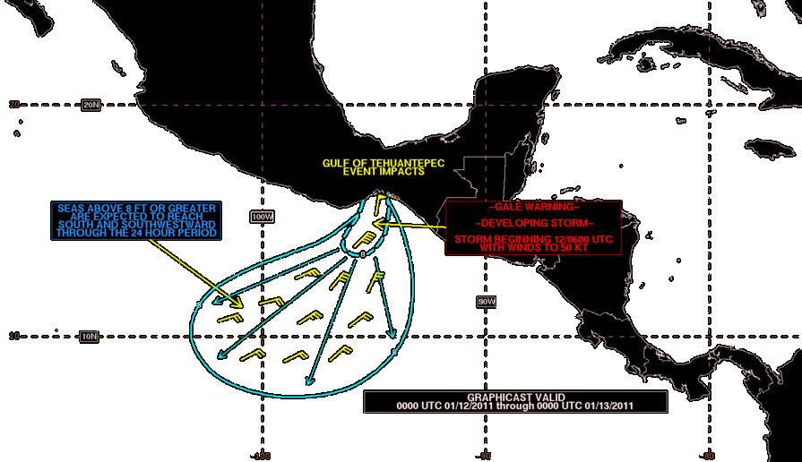
 Public domain, NOAA Tropical Analysis and Forecast Branch, Wikimedia Commons
Seasonal· Gulf of Tehuantepec· Mexico
Tehuantepecer Winds
15° 48.0′ N · 94° 54.0′ W · approximate
The Tehuano: a violent gap wind that pours through the Chivela Pass across the Isthmus of Tehuantepec after cold fronts reach the Gulf of Mexico, typically 20-45 knots and occasionally storm or hurricane force, with steep seas felt up to 100 miles offshore.
Practical
Approximate: a mid-gulf reference point. Most common October to February, least in July; events last from hours to several days, and El Niño winters bring more of them. Seen from Huatulco, it can blow 60+ mph with seas to 20 ft roughly weekly in winter (Roads Less Traveled). Plan a window of at least three calm days and use gust values, not averages (Practical Sailor); check PredictWind, Windy, Passage Weather and NOAA's TAFB high-seas forecasts, which often use UTC. Roads Less Traveled took the coastal route 0.25-0.5 mile off the beach, where seas stayed much flatter than offshore. Caribbean weather systems can also funnel strong winds through Central American gaps.
Best for
Planning a safe Gulf of Tehuantepec crossing
Season
Oct-Feb peak; possible year-round
Nearby
- Salina Cruz28.6 NM away
- Bahía Chipehua Anchorage30.9 NM away
- Puerto Arista Beach Anchorage (Chiapas)63.5 NM away
- Copalita Eco-Archaeological Park (Huatulco)66.8 NM away
- Bahía Conejos Anchorage (Huatulco)67.4 NM away
- Isla Montosa Dive Site (Bahía Conejos)68.4 NM away
- Bahía Tangolunda68.9 NM away
- Punta Arrocito Dive Site69.3 NM away